
Make a donation
Gear up for your next adventure:
As an Amazon Associate, this site earns from qualifying purchases at no extra cost to you.
Cocotitlán topographic map
Click on the map to display elevation.
Make a donation
Gear up for your next adventure:
As an Amazon Associate, this site earns from qualifying purchases at no extra cost to you.
About this map
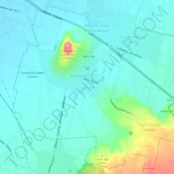
Name: Cocotitlán topographic map, elevation, terrain.
Location: Cocotitlán, Estado de México, 56680, México (19.20559 -98.88144 19.24984 -98.83171)
Average elevation: 2,273 m
Minimum elevation: 2,243 m
Maximum elevation: 2,403 m
Make a donation
Gear up for your next adventure:
As an Amazon Associate, this site earns from qualifying purchases at no extra cost to you.
Other topographic maps
Click on a map to view its topography, its elevation and its terrain.
Cerro Catedral
México > Estado de México > Isidro Fabela > Tlazala De Fabela
Average elevation: 3,227 m
Chiautla
México > Estado de México > Chiautla
El municipio se encuentra a una altitud de 2,258 metros sobre el nivel del mar. El municipio de Chiautla se localiza en la porción oriente del Estado de México y colinda la norte con el municipio de Acolman, al sur con el municipio de Texcoco, al oriente con los municipios de Tepetlaoxtoc y Papalotla; y al…
Average elevation: 2,261 m
Make a donation
Gear up for your next adventure:
As an Amazon Associate, this site earns from qualifying purchases at no extra cost to you.
La Cúspide
México > Estado de México > Naucalpan de Juárez > San Mateo Nopala
Average elevation: 2,377 m
Make a donation
Gear up for your next adventure:
As an Amazon Associate, this site earns from qualifying purchases at no extra cost to you.
Make a donation
Gear up for your next adventure:
As an Amazon Associate, this site earns from qualifying purchases at no extra cost to you.
San Miguel Hojas Anchas
México > Estado de México > Zinacantepec > Barrio De México
Average elevation: 2,960 m
El Calvario
México > Estado de México > Atlacomulco > Atlacomulco de Fabela
Average elevation: 2,571 m
Make a donation
Gear up for your next adventure:
As an Amazon Associate, this site earns from qualifying purchases at no extra cost to you.
San Pedro Huitzizilapan
México > Estado de México > San Pedro Huitzizilapan
Average elevation: 2,687 m
Make a donation
Gear up for your next adventure:
As an Amazon Associate, this site earns from qualifying purchases at no extra cost to you.
Laguna de Ojuelos
México > Estado de México > Zinacantepec > San Luis Mextepec
Average elevation: 2,718 m
San Miguel Xaltocan
México > Estado de México > Nextlalpan > San Miguel Xaltocan
Average elevation: 2,241 m
Make a donation
Gear up for your next adventure:
As an Amazon Associate, this site earns from qualifying purchases at no extra cost to you.