Geolocate

Johnstown topographic map

Click on the map to display elevation.

About this map

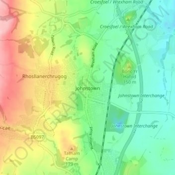
Name: Johnstown topographic map, elevation, terrain.

Location: Johnstown, Wrexham, Wales, LL14 2SN, United Kingdom (52.99007 -3.06294 53.03007 -3.02294)

Average elevation: 137 m

Minimum elevation: 79 m

Maximum elevation: 234 m

Wrexham trails, hiking, mountain biking, running and outdoor activities

Other topographic maps

Click on a map to view its topography, its elevation and its terrain.

Penycae

United Kingdom > Wales > Wrexham

Average elevation: 350 m

Rhosddu

United Kingdom > Wales > Wrexham

Average elevation: 88 m

Gwersyllt

United Kingdom > Wales > Wrexham

Average elevation: 112 m

Bangor-on-Dee

United Kingdom > Wales > Wrexham

Average elevation: 30 m

Cefn

United Kingdom > Wales > Wrexham > Acrefair

Average elevation: 142 m

Gear up for your next adventure:

🧰First Aid Kits - Essential safety kits for outdoor activities
👕Merino Base Layers - Natural temperature regulation for cold weather hiking and camping
🦯Walking Poles - Supportive poles for long-distance walking
📚UK Hiking Guidebooks - Detailed route descriptions for the Lake District, Peaks, and Highlands
🪓Outdoor Multitools - Versatile tools for hiking and camping

As an Amazon Associate, this site earns from qualifying purchases at no extra cost to you.