
Viterbe topographic map
Interactive map
Click on the map to display elevation.
About this map
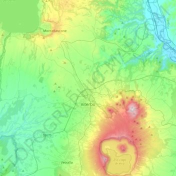
Name: Viterbe topographic map, elevation, terrain.
Location: Viterbe, Latium, Italie (42.29815 11.90455 42.58823 12.22484)
Average elevation: 330 m
Minimum elevation: 54 m
Maximum elevation: 1,065 m
Viterbe est le chef-lieu de la province du même nom, au nord-ouest de la région du Latium. Située dans un relief d'altitude moyenne (326 mètres), elle est située à vol d'oiseau à 65 km au nord-ouest de Rome, 40 km au nord-est de Civitavecchia, 92 km au sud-est de Grosseto et 47 km à l'ouest sud-ouest de Terni.
Other topographic maps
Click on a map to view its topography, its elevation and its terrain.
SIC Monti di Castro
Italie > Latium > Viterbe > Ischia di Castro
SIC Monti di Castro, Ischia di Castro, Unione di Comuni Montani Colline del Fiora, Viterbe, Latium, Italie
Average elevation: 259 m
Poggio Morello
Italie > Latium > Viterbe > Viterbe
Poggio Morello, Viterbe, Latium, 01026, Italie
Average elevation: 213 m
Montalto di Castro
Montalto di Castro, Viterbe, Latium, 01014, Italie
Average elevation: 48 m
Montefiascone
Montefiascone, Viterbe, Latium, 01027, Italie
Average elevation: 375 m
San Lorenzo Nuovo
San Lorenzo Nuovo, Viterbe, Latium, Italie
Average elevation: 404 m
Pisciarello
Italie > Latium > Viterbe > Graffignano
Pisciarello, Graffignano, Viterbe, Latium, Italie
Average elevation: 104 m