
Tórshavn topographic map
Interactive map
Click on the map to display elevation.
About this map
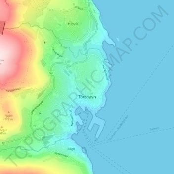
Name: Tórshavn topographic map, elevation, terrain.
Location: Tórshavn, Streymoy region, 100, Faroe Islands (61.99638 -6.85849 62.03315 -6.75269)
Average elevation: 68 m
Minimum elevation: -4 m
Maximum elevation: 342 m
Other topographic maps
Click on a map to view its topography, its elevation and its terrain.
Streymoy
Faroe Islands > Streymoy region
Streymoy, Streymoy region, Faroe Islands
Average elevation: 133 m
Streymoy
Faroe Islands > Streymoy region > Stykkið
Streymoy, Stykkið, Streymoy region, 330, Faroe Islands
Average elevation: 60 m
Válur
Faroe Islands > Streymoy region > Válur
Válur, Streymoy region, 358, Faroe Islands
Average elevation: 181 m
Hósvík
Faroe Islands > Streymoy region
Hósvík, Streymoy region, 420, Faroe Islands
Average elevation: 243 m