Geolocate

Uis topographic map

Click on the map to display elevation.

About this map

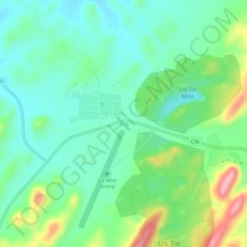
Name: Uis topographic map, elevation, terrain.

Location: Uis, Erongo Region, Namibia (-21.24077 14.85092 -21.20077 14.89092)

Average elevation: 819 m

Minimum elevation: 772 m

Maximum elevation: 933 m

Other topographic maps

Click on a map to view its topography, its elevation and its terrain.

Henties Bay

Namibia > Erongo Region

Average elevation: 21 m

Arandis

Namibia > Erongo Region

Average elevation: 583 m

Arandis

Namibia > Erongo Region

Average elevation: 583 m

Henties Bay

Namibia > Erongo Region > Henties Bay

Average elevation: 24 m

Henties Bay

Namibia > Erongo Region

Average elevation: 21 m

Usakos

Namibia > Erongo Region

Average elevation: 890 m

Karibib

Namibia > Erongo Region > Karibib

Average elevation: 1,180 m

Omaruru

Namibia > Erongo Region

Average elevation: 1,222 m

Omaruru

Namibia > Erongo Region > Omaruru

Average elevation: 1,222 m

Gear up for your next adventure:

🎒Hiking Daypacks (20L) - Compact backpacks for day trips and technical mountain ascents
Insulated Travel Mugs - Keep drinks hot while surveying the landscape from a summit
🥄Titanium Camping Sporks - The ultimate lightweight utensil for trail meals
🧵Survival Paracord - Multi-purpose cordage for emergency repairs and shelters
👖Hiking Trousers - Durable trousers designed for rough terrain

As an Amazon Associate, this site earns from qualifying purchases at no extra cost to you.