
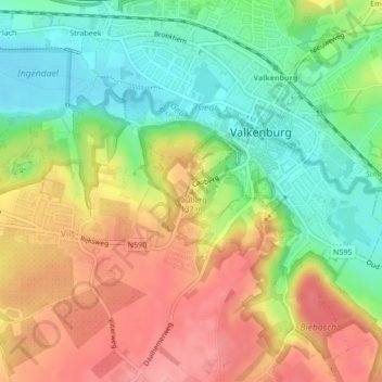
Cauberg topographic map
Interactive map
Click on the map to display elevation.
About this map
Name: Cauberg topographic map, elevation, terrain.
Average elevation: 108 m
Minimum elevation: 61 m
Maximum elevation: 159 m
Other topographic maps
Click on a map to view its topography, its elevation and its terrain.
Sint Gerlach
Nederland > Limburg > Valkenburg > Houthem
Sint Gerlach, Houthem, Valkenburg, Valkenburg aan de Geul, Limburg, Nederland, 6301 JC, Nederland
Average elevation: 107 m
Houthem
Nederland > Limburg > Valkenburg
Houthem, Valkenburg, Valkenburg aan de Geul, Limburg, Nederland, 6301 JD, Nederland
Average elevation: 105 m
Sibbe
Nederland > Limburg > Valkenburg
Sibbe, Valkenburg, Valkenburg aan de Geul, Limburg, Nederland, 6301 AR, Nederland
Average elevation: 138 m
Valkenburg
Nederland > Limburg > Valkenburg
Valkenburg, Limburg, Nederland, 6301, Nederland
Average elevation: 121 m