
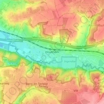
Houthem topographic map
Interactive map
Click on the map to display elevation.
About this map
Name: Houthem topographic map, elevation, terrain.
Average elevation: 105 m
Minimum elevation: 49 m
Maximum elevation: 152 m
Houthem ligt in de vallei van de Geul, aan de rechteroever, op een hoogte van ongeveer 60 meter. In de omgeving van Houthem liggen diverse hellingbossen (waaronder op de noordhelling van het Geuldal het Kloosterbosch) en in het Geuldal het natuurontwikkelingsgebied Ingendael.
Other topographic maps
Click on a map to view its topography, its elevation and its terrain.
Sint Gerlach
Nederland > Limburg > Valkenburg > Houthem
Sint Gerlach, Houthem, Valkenburg, Valkenburg aan de Geul, Limburg, Nederland, 6301 JC, Nederland
Average elevation: 107 m
Cauberg
Nederland > Limburg > Valkenburg
Cauberg, Valkenburg, Valkenburg aan de Geul, Limburg, Nederland, 6301 BV, Nederland
Average elevation: 108 m
Sibbe
Nederland > Limburg > Valkenburg
Sibbe, Valkenburg, Valkenburg aan de Geul, Limburg, Nederland, 6301 AR, Nederland
Average elevation: 138 m
Valkenburg
Nederland > Limburg > Valkenburg
Valkenburg, Limburg, Nederland, 6301, Nederland
Average elevation: 121 m