
Shurabak topographic map
Interactive map
Click on the map to display elevation.
Shurabak
Shorabak District (also Shorawak ) is a remote district situated in the southeastern part of Kandahar Province, Afghanistan, 110 km south and east of Kandahar. It borders Reg District to the west, Spin Boldak District to the north and Pakistan to the east and south. The population is 10,200 (2006). The district center Shorabak is located on 30°11′00″N 66°06′00″E / 30.1833°N 66.1000°E / 30.1833; 66.1000 at 985 m altitude in the Eastern part of the district.
About this map
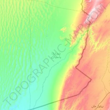
Name: Shurabak topographic map, elevation, terrain.
Location: Shurabak, Kandahar Province, Afghanistan (29.72940 65.80473 30.59888 66.37347)
Average elevation: 1,243 m
Minimum elevation: 912 m
Maximum elevation: 2,258 m
Other topographic maps
Click on a map to view its topography, its elevation and its terrain.
Kandahar
Afghanistan > Kandahar Province > Kandahar
Kandahar (English: /ˈkændəhɑːr/; Pashto: کندهار Kandahār, Dari: قندهار, Qandahār) is a city in Afghanistan, located in the south of the country on the Arghandab River, at an elevation of 1,010 m (3,310 ft). It is Afghanistan's second largest city after Kabul, with a population of about…
Average elevation: 1,048 m