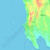
Mara Region topographic map
Click on the map to display elevation.
About this map
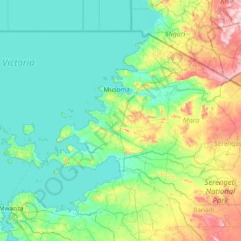
Name: Mara Region topographic map, elevation, terrain.
Location: Mara Region, Lake Zone, Tanzania (-2.50521 33.20112 -1.02892 35.26670)
Average elevation: 1,262 m
Minimum elevation: 1,130 m
Maximum elevation: 2,067 m
Other topographic maps
Click on a map to view its topography, its elevation and its terrain.
Kilimanjaro
Mount Kilimanjaro (/ˌkɪlɪmənˈdʒɑːroʊ/) is a dormant volcano in Tanzania. It is the highest mountain in Africa and the highest free-standing mountain above sea level in the world: 5,895 m (19,341 ft) above sea level and 4,900 m (16,100 ft) above its plateau base. It is also the highest volcano in the…
Average elevation: 1,537 m
Arusha
Despite its proximity to the equator, Arusha's elevation of 1,400 metres (4,600 ft) on the southern slopes of Mount Meru keeps temperatures relatively low and alleviates humidity. Cool dry air is prevalent for much of the year. The temperature typically ranges between 10 and 30 °C (50 and 86 °F) with an…
Average elevation: 1,572 m



Mount Meru
Mount Meru is the topographic centerpiece of Arusha National Park. Its fertile slopes rise above the surrounding savanna and support a forest that hosts diverse wildlife, including nearly 400 species of birds, as well as monkeys and leopards.
Average elevation: 3,881 m




Kilimanjaro
The mountain was incorporated into Kilimanjaro National Park in 1973. As one of the Seven Summits, Kilimanjaro is a major hiking and climbing destination. There are seven established routes to Uhuru Peak, the mountain's highest point. Although not as technically challenging as similar mountains, the prominence…
Average elevation: 1,537 m
Bukoba
Bukoba has an upland tropical monsoon climate (Köppen Amb, because every month has a normal mean temperature of between 18 °C and 22 °C) although it is milder than most climates with that classification due to its altitude. It can sometimes get cool especially in the evenings during the two rainy seasons,…
Average elevation: 1,177 m
Kilimanjaro
The mountain was incorporated into Kilimanjaro National Park in 1973. As one of the Seven Summits, Kilimanjaro is a major hiking and climbing destination. There are seven established routes to Uhuru Peak, the mountain's highest point. Although not as technically challenging as similar mountains, the prominence…
Average elevation: 1,537 m


Mbeya
Mbeya is situated at an altitude of 1,700 metres (5,500 ft), and sprawls through a narrow highland valley surrounded by a bowl of high mountains. The main language is colloquial Swahili, and the English language is extensively taught in schools.
Average elevation: 1,817 m


Dodoma
The official capital since 1996, Dodoma was envisaged as the first non-monumental capital city as opposed to the monumentality and hierarchy of other planned capital cities such as Abuja, Yamoussoukro, Brasília and Washington, D.C. It rejected geometrical forms such as grid iron and radial plans as…
Average elevation: 1,143 m




Arusha
Despite its proximity to the equator, Arusha's elevation of 1,400 metres (4,600 ft) on the southern slopes of Mount Meru keeps temperatures relatively low and alleviates humidity. Cool dry air is prevalent for much of the year. The temperature typically ranges between 10 and 30 °C (50 and 86 °F) with an…
Average elevation: 1,572 m
Mwanza
Mwanza features a tropical savanna climate under the Köppen climate classification. Temperatures are relatively consistent throughout the course of the year, tempered by the city's altitude. Thus, the climate is not quite as hot as one might expect, given the city's location near the equator. Average…
Average elevation: 1,178 m


Kibo
The mountain was incorporated into Kilimanjaro National Park in 1973. As one of the Seven Summits, Kilimanjaro is a major hiking and climbing destination. There are seven established routes to Uhuru Peak, the mountain's highest point. Although not as technically challenging as similar mountains, the prominence…
Average elevation: 5,664 m
Kilimanjaro
Kilimanjaro is the fourth most topographically prominent peak on Earth. It is part of Kilimanjaro National Park and is a major hiking and climbing destination. Because of its shrinking glaciers and ice fields, which are projected to disappear between 2025 and 2035, it has been the subject of many scientific…
Average elevation: 1,537 m
Dodoma
The official capital since 1996, Dodoma was envisaged as the first non-monumental capital city as opposed to the monumentality and hierarchy of other planned capital cities such as Abuja, Yamoussoukro, Brasília and Washington, D.C. It rejected geometrical forms such as grid iron and radial plans as…
Average elevation: 1,143 m


Moshi
Moshi's lower altitude and drier climate mean that the main crops grown on the higher slopes of Mt Kilimanjaro, coffee and bananas, do not thrive there. The surrounding areas in Moshi district are known for extensive farms of maize and beans, grown once per year during the long rainy season (known as "masika"…
Average elevation: 1,109 m


Dodoma
The official capital since 1996, Dodoma was envisaged as the first non-monumental capital city as opposed to the monumentality and hierarchy of other planned capital cities such as Abuja, Yamoussoukro, Brasília and Washington, D.C. It rejected geometrical forms such as grid iron and radial plans as…
Average elevation: 1,143 m
Moshi
Moshi's lower altitude and drier climate mean that the main crops grown on the higher slopes of Mt Kilimanjaro, coffee and bananas, do not thrive there. The surrounding areas in Moshi district are known for extensive farms of maize and beans, grown once per year during the long rainy season (known as "masika"…
Average elevation: 1,109 m
Kilimanjaro
Mount Kilimanjaro (/ˌkɪlɪmənˈdʒɑːroʊ/) is a dormant volcano in Tanzania. It is the highest mountain in Africa and the highest free-standing mountain above sea level in the world: 5,895 m (19,341 ft) above sea level and 4,900 m (16,100 ft) above its plateau base. It is also the highest volcano in the…
Average elevation: 1,537 m
Ol Doinyo Lengai
Vegetation in the area consists mostly of grassland, which reaches an elevation of 1,750 metres (5,740 ft) above sea level. Volcanic ash from Ol Doinyo Lengai influences the surrounding landscape, favoring the growth of nutrient-rich plants. Precipitation falls during two wet seasons in March–May and…
Average elevation: 2,356 m

Mbeya
Mbeya is situated at an altitude of 1,700 metres (5,500 ft), and sprawls through a narrow highland valley surrounded by a bowl of high mountains. The main language is colloquial Swahili, and the English language is extensively taught in schools.
Average elevation: 1,817 m


Iringa
The town stretches along a hilltop overlooking the Little Ruaha River to the south, and spreads along ridges and valleys to the north. Iringa is in the Udzungwa Mountains, and the altitude of the town's environs is more than 1,550 metres (5,090 ft) above sea level. The months of June, July, and August can see…
Average elevation: 1,571 m
Dodoma
The official capital since 1996, Dodoma was envisaged as the first non-monumental capital city as opposed to the monumentality and hierarchy of other planned capital cities such as Abuja, Yamoussoukro, Brasília and Washington, D.C. It rejected geometrical forms such as grid iron and radial plans as…
Average elevation: 1,143 m
Mbeya
Mbeya is situated at an altitude of 1,700 metres (5,500 ft), and sprawls through a narrow highland valley surrounded by a bowl of high mountains. The main language is colloquial Swahili, and the English language is extensively taught in schools.
Average elevation: 1,817 m


Arusha
Despite its proximity to the equator, Arusha's elevation of 1,400 metres (4,600 ft) on the southern slopes of Mount Meru keeps temperatures relatively low and alleviates humidity. Cool dry air is prevalent for much of the year. The temperature typically ranges between 10 and 30 °C (50 and 86 °F) with an…
Average elevation: 1,572 m
Kilimanjaro
Mount Kilimanjaro (/ˌkɪlɪmənˈdʒɑːroʊ/) is a dormant volcano in Tanzania. It is the highest mountain in Africa and the highest free-standing mountains above sea level in the world, at 5,895 m (19,341 ft) above sea level and 4,900 m (16,100 ft) above its plateau base. It is also the highest volcano in…
Average elevation: 1,537 m
Bukoba
Bukoba has an upland tropical monsoon climate (Köppen Amb, because every month has a normal mean temperature of between 18 °C and 22 °C) although it is milder than most climates with that classification due to its altitude. It can sometimes get cool especially in the evenings during the two rainy seasons,…
Average elevation: 1,177 m
Kilimanjaro
Mount Kilimanjaro (/ˌkɪlɪmənˈdʒɑːroʊ/) is a dormant volcano in Tanzania. It is the highest mountain in Africa and the highest free-standing mountain above sea level in the world, situated at 5,895 m (19,341 ft) above sea level and 4,900 m (16,100 ft) above its plateau base. It is also the highest…
Average elevation: 1,537 m