
Schlieren topographic map
Interactive map
Click on the map to display elevation.
About this map
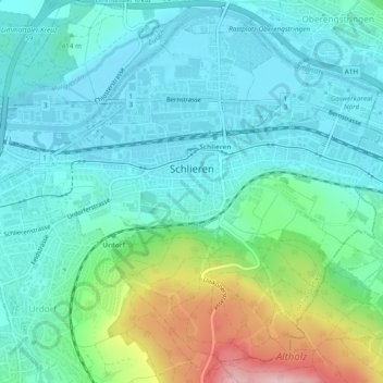
Name: Schlieren topographic map, elevation, terrain.
Location: Schlieren, Bezirk Dietikon, Zürich, 8952, Schweiz (47.38025 8.42579 47.40888 8.47349)
Average elevation: 440 m
Minimum elevation: 386 m
Maximum elevation: 618 m
Other topographic maps
Click on a map to view its topography, its elevation and its terrain.
Aesch (ZH)
Schweiz > Zürich > Bezirk Dietikon
Aesch (ZH), Bezirk Dietikon, Zürich, 8904, Schweiz
Average elevation: 580 m
Ringlikon
Schweiz > Zürich > Bezirk Dietikon > Waldegg
Ringlikon, Waldegg, Uitikon, Bezirk Dietikon, Zürich, 8142, Schweiz
Average elevation: 575 m