
Allschwil topographic map
Interactive map
Click on the map to display elevation.
About this map
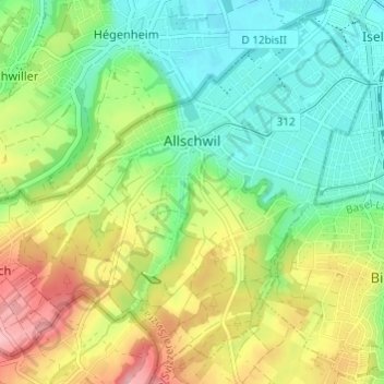
Name: Allschwil topographic map, elevation, terrain.
Location: Allschwil, Bezirk Arlesheim, Basel-Landschaft, 4123, Schweiz (47.52684 7.50410 47.56437 7.56458)
Average elevation: 321 m
Minimum elevation: 270 m
Maximum elevation: 404 m
Other topographic maps
Click on a map to view its topography, its elevation and its terrain.
Muttenz
Schweiz > Basel-Landschaft > Bezirk Arlesheim
Muttenz, Bezirk Arlesheim, Basel-Landschaft, 4132, Schweiz
Average elevation: 341 m
Schönenbuch
Schweiz > Basel-Landschaft > Bezirk Arlesheim
Schönenbuch, Bezirk Arlesheim, Basel-Landschaft, 4124, Schweiz
Average elevation: 367 m