
Muttenz topographic map
Interactive map
Click on the map to display elevation.
About this map
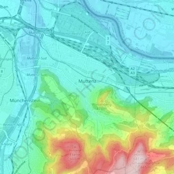
Name: Muttenz topographic map, elevation, terrain.
Location: Muttenz, Bezirk Arlesheim, Basel-Landschaft, 4132, Schweiz (47.49457 7.62158 47.55169 7.67509)
Average elevation: 341 m
Minimum elevation: 255 m
Maximum elevation: 666 m
Muttenz ist ein Standort der Fachhochschule Nordwestschweiz mit den Bereichen Architektur, Bau und Geomatik, Life Sciences, Technik und Pädagogik. Ausserdem befinden sich in Muttenz ein kantonales Gymnasium mit Fachmittelschule, die Höhere Fachschule für Informations- und Kommunikationstechnologie, das Berufsbildungszentrum Baselland (BBZ BL) und das Ausbildungszentrum (Berufsfachschule und Werkschule) von aprentas (Standort Muttenz mit den Berufen Laborant sowie Chemie- und Pharmatechnologe).
Other topographic maps
Click on a map to view its topography, its elevation and its terrain.
Allschwil
Schweiz > Basel-Landschaft > Bezirk Arlesheim
Allschwil, Bezirk Arlesheim, Basel-Landschaft, 4123, Schweiz
Average elevation: 321 m
Schönenbuch
Schweiz > Basel-Landschaft > Bezirk Arlesheim
Schönenbuch, Bezirk Arlesheim, Basel-Landschaft, 4124, Schweiz
Average elevation: 367 m