Geolocate

Wum topographic map

Click on the map to display elevation.

About this map

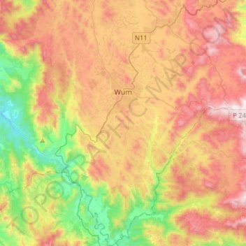
Name: Wum topographic map, elevation, terrain.

Location: Wum, Menchum, Northwest, Cameroon (6.22747 10.00732 6.48346 10.16890)

Average elevation: 987 m

Minimum elevation: 435 m

Maximum elevation: 1,577 m

Other topographic maps

Click on a map to view its topography, its elevation and its terrain.

Nyos

Cameroon > Northwest > Menchum

Average elevation: 1,262 m

Melang

Cameroon > Northwest > Menchum

Average elevation: 1,086 m

Gear up for your next adventure:

🧤Hiking Gloves - Warm and durable gloves for cold-weather walks
🧼Camping Hygiene Kits - Compact hygiene essentials for outdoor stays
🔦Waterproof LED Headlamps - Hands-free lighting for evening treks and emergency navigation
🪓Outdoor Multitools - Versatile tools for hiking and camping
👖Packable Overtrousers - Quick-deploy rain protection for legs in sudden storms

As an Amazon Associate, this site earns from qualifying purchases at no extra cost to you.