Geolocate

Malava topographic map

Click on the map to display elevation.

About this map

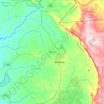
Name: Malava topographic map, elevation, terrain.

Location: Malava, Kakamega County, Kenya (0.33274 34.71032 0.60470 34.95710)

Average elevation: 1,611 m

Minimum elevation: 1,403 m

Maximum elevation: 2,145 m

Other topographic maps

Click on a map to view its topography, its elevation and its terrain.

Mumias

Kenya > Kakamega County > Mumias West > Mumias Central ward

Average elevation: 1,297 m

Mumias

Kenya > Kakamega County > Mumias West > Mumias Central ward

Average elevation: 1,301 m

Kakamega

Kenya > Kakamega County

Kakamega is 52 km north of Kisumu, the tenth largest city in Kenya and considered the heart of Luhya land. The average elevation of Kakamega is 1,535 metres.

Average elevation: 1,533 m

Matisi B

Kenya > Kakamega County > Likuyani > Nzoia ward

Average elevation: 1,793 m

Shibuli

Kenya > Kakamega County > Lurambi > Butsotso central ward

Average elevation: 1,375 m

Hill

Kenya > Kakamega County > Shinyalu > Isukha East ward

Average elevation: 1,616 m

Mumias

Kenya > Kakamega County > Mumias West > Mumias Central ward

Average elevation: 1,297 m

Matunda

Kenya > Kakamega County

Average elevation: 1,841 m

Gear up for your next adventure:

🎒Hiking Daypacks - Compact backpacks ideal for short hikes and excursions
🛌Insulated Sleeping Mats - Crucial thermal protection when sleeping on cold, uneven ground
🥾Women's Waterproof Hiking Boots - High-performance trekking boots designed for all-weather comfort
🔦Head Torches - Hands-free lighting for hiking and camping
🐕Dog Hiking Gear - Equipment for hiking safely with dogs

As an Amazon Associate, this site earns from qualifying purchases at no extra cost to you.