
Viedma-See topographic map
Interactive map
Click on the map to display elevation.
About this map
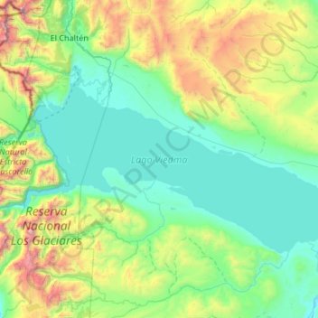
Name: Viedma-See topographic map, elevation, terrain.
Location: Viedma-See, Lago Argentino, SC, Argentinien (-49.80399 -73.04000 -49.39296 -71.96937)
Average elevation: 784 m
Minimum elevation: 188 m
Maximum elevation: 3,270 m
Other topographic maps
Click on a map to view its topography, its elevation and its terrain.
Puerto San Julián
Argentinien > SC > Puerto San Julián > Puerto San Julián
Puerto San Julián, Magallanes, SC, Argentinien
Average elevation: 8 m
Veintiocho de Noviembre
Argentinien > SC > Veintiocho de Noviembre
Veintiocho de Noviembre, Río Turbio, Güer Aike, SC, 9408, Argentinien
Average elevation: 267 m
Macrozona Lago Argentino
Macrozona Lago Argentino, El Calafate, Lago Argentino, SC, Argentinien
Average elevation: 201 m
El Calafate
El Calafate, Lago Argentino, SC, Z9405, Argentinien
Average elevation: 336 m