
El Calafate topographic map
Interactive map
Click on the map to display elevation.
About this map
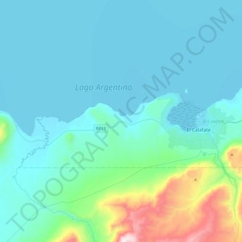
Name: El Calafate topographic map, elevation, terrain.
Location: El Calafate, Lago Argentino, SC, Z9405, Argentinien (-50.37571 -72.52231 -50.28511 -72.14846)
Average elevation: 336 m
Minimum elevation: 177 m
Maximum elevation: 1,424 m
Other topographic maps
Click on a map to view its topography, its elevation and its terrain.
Puerto San Julián
Argentinien > SC > Puerto San Julián > Puerto San Julián
Puerto San Julián, Magallanes, SC, Argentinien
Average elevation: 8 m
Veintiocho de Noviembre
Argentinien > SC > Veintiocho de Noviembre
Veintiocho de Noviembre, Río Turbio, Güer Aike, SC, 9408, Argentinien
Average elevation: 267 m
Macrozona Lago Argentino
Macrozona Lago Argentino, El Calafate, Lago Argentino, SC, Argentinien
Average elevation: 201 m