
Make a donation
Gear up for your next adventure:
As an Amazon Associate, this site earns from qualifying purchases at no extra cost to you.
Machapuchare topographic map
Click on the map to display elevation.
Make a donation
Gear up for your next adventure:
As an Amazon Associate, this site earns from qualifying purchases at no extra cost to you.
Machapuchare
Due to its southern position in the range and the particularly low terrain that lies south of the Annapurna Himalayas, which contains three of the 10 highest peaks in the world, Machapuchare commands tremendous vertical relief in a short horizontal distance. This, combined with its steep, pointed profile, makes it a particularly striking peak, despite its lower elevation than some of its neighbors. Its double summit resembles the tail of a fish, hence the name meaning "fish's tail" in Nepalese. It is also nicknamed the "Matterhorn of Nepal".
Make a donation
Gear up for your next adventure:
As an Amazon Associate, this site earns from qualifying purchases at no extra cost to you.
About this map
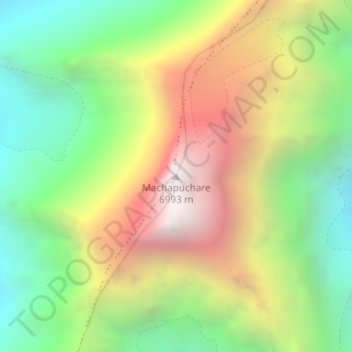
Name: Machapuchare topographic map, elevation, terrain.
Location: Machapuchare, Machhapuchchhre, Kaski, Gandaki Province, Nepal (28.49793 83.94583 28.49803 83.94593)
Average elevation: 5,746 m
Minimum elevation: 4,851 m
Maximum elevation: 6,928 m
Make a donation
Gear up for your next adventure:
As an Amazon Associate, this site earns from qualifying purchases at no extra cost to you.
Other topographic maps
Click on a map to view its topography, its elevation and its terrain.
Phewa Lake
Nepal > Gandaki Province > Kaski > Pokhara
Phewa Lake, Phewa Tal or Fewa Lake (Nepali: फेवा ताल, [ˈpʰewa tal]) is a freshwater lake in Nepal formerly called Baidam Tal located in the south of the Pokhara Valley that includes Pokhara city and parts of Sarangkot and Kaskikot. It is the second largest lake in Nepal and the largest in…
Average elevation: 884 m