Geolocate

Gilfach Goch topographic map

Click on the map to display elevation.

About this map

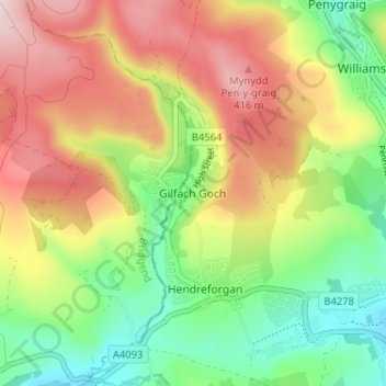
Name: Gilfach Goch topographic map, elevation, terrain.

Location: Gilfach Goch, Rhondda Cynon Taf, Wales, CF39 8SR, United Kingdom (51.57358 -3.49140 51.61358 -3.45140)

Average elevation: 266 m

Minimum elevation: 123 m

Maximum elevation: 436 m

Rhondda Cynon Taf trails, hiking, mountain biking, running and outdoor activities

Other topographic maps

Click on a map to view its topography, its elevation and its terrain.

Mid Glamorgan

United Kingdom > Wales > Rhondda Cynon Taf

Average elevation: 235 m

Pontypridd

United Kingdom > Wales > Rhondda Cynon Taf

Average elevation: 183 m

Penrhiwceiber

United Kingdom > Wales > Rhondda Cynon Taf

Average elevation: 229 m

Pontypridd

United Kingdom > Wales > Rhondda Cynon Taf

Average elevation: 183 m

Trealaw

United Kingdom > Wales > Rhondda Cynon Taf > Tonypandy

Average elevation: 222 m

Gear up for your next adventure:

🪓Outdoor Multitools - Versatile tools for hiking and camping
🧢Waterproof Hiking Hats - Keep the rain off your face while studying topographic maps
🌄Outdoor Binoculars - Compact binoculars for landscape observation
👟Women's Trail Running Shoes - Agile footwear for fell running and technical trails
👖Hiking Trousers - Durable trousers designed for rough terrain

As an Amazon Associate, this site earns from qualifying purchases at no extra cost to you.