Geolocate

Tral topographic map

Click on the map to display elevation.

About this map

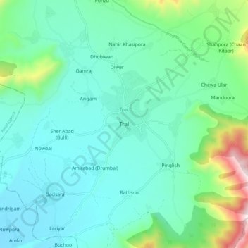
Name: Tral topographic map, elevation, terrain.

Location: Tral, Pulwama District, Jammu and Kashmir, 192123, India (33.88655 75.07404 33.96655 75.15404)

Average elevation: 1,791 m

Minimum elevation: 1,600 m

Maximum elevation: 2,569 m

Other topographic maps

Click on a map to view its topography, its elevation and its terrain.

Batagund

India > Jammu and Kashmir > Tral

Average elevation: 1,771 m

Gear up for your next adventure:

🧘Folding Sit Mats - Dry and warm seat for map-reading breaks on damp ground
🐕Dog Hiking Gear - Equipment for hiking safely with dogs
🧣Neck Gaiters - Versatile protection against wind and cold
🗺️Ordnance Survey Maps - Official UK maps for walking and outdoor activities
👖Packable Overtrousers - Quick-deploy rain protection for legs in sudden storms

As an Amazon Associate, this site earns from qualifying purchases at no extra cost to you.