
Rootok Island topographic map
Interactive map
Click on the map to display elevation.
About this map
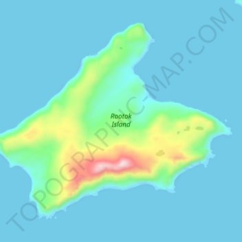
Name: Rootok Island topographic map, elevation, terrain.
Location: Rootok Island, Aleutians East, Alaska, United States (54.02390 -165.57346 54.06719 -165.48261)
Average elevation: 60 m
Minimum elevation: -14 m
Maximum elevation: 460 m
Other topographic maps
Click on a map to view its topography, its elevation and its terrain.
Shishaldin Volcano
United States > Alaska > Aleutians East
Shishaldin Volcano, or Mount Shishaldin (/ʃɪˈʃældən/), is a moderately active volcano on Unimak Island in the Aleutian Islands chain of Alaska in the United States. It is the highest mountain peak of the Aleutian Islands and rises about 10,000 m (33,000 ft) from the bottom of the Aleutian Trench 140 mi…
Average elevation: 2,134 m