
حديقة سترة الكبرى topographic map
Interactive map
Click on the map to display elevation.
About this map
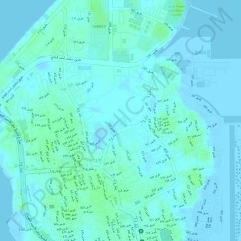
Name: حديقة سترة الكبرى topographic map, elevation, terrain.
Location: حديقة سترة الكبرى, Manama, Capital Governorate, 604, Bahrain (26.17053 50.61661 26.17063 50.61671)
Average elevation: 3 m
Minimum elevation: -1 m
Maximum elevation: 9 m
Other topographic maps
Click on a map to view its topography, its elevation and its terrain.
Nabih Saleh
Bahrain > Capital Governorate > Manama
Nabih Saleh, Manama, Capital Governorate, 604, Bahrain
Average elevation: 2 m
Bahrain Bay
Bahrain > Capital Governorate > Manama
Bahrain Bay, Manama, Capital Governorate, 346, Bahrain
Average elevation: 2 m