
Salgesch topographic map
Interactive map
Click on the map to display elevation.
About this map
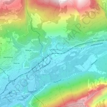
Name: Salgesch topographic map, elevation, terrain.
Location: Salgesch, Leuk, Wallis, 3970, Schweiz (46.27591 7.55011 46.34225 7.59441)
Average elevation: 979 m
Minimum elevation: 517 m
Maximum elevation: 2,135 m
Other topographic maps
Click on a map to view its topography, its elevation and its terrain.
Illhorn
Schweiz > Wallis > Leuk > Leuk Stadt
Illhorn, Leuk Stadt, Leuk, Wallis, 3952, Schweiz
Average elevation: 2,165 m
Gampel
Schweiz > Wallis > Leuk > Gampel-Bratsch
Gampel, Gampel-Bratsch, Leuk, Wallis, 3940, Schweiz
Average elevation: 982 m