Geolocate

Karur topographic map

Click on the map to display elevation.

Karur

Karur is located at 10°57′N 78°05′E / 10.95°N 78.08°E / 10.95; 78.08 and has an average elevation of 101 metres or 331 feet. The town is located in Karur district of the South Indian state, Tamil Nadu, at a distance of 370 km (230 mi) from Chennai.

Wikipedia (CC-BY-SA 3.0)

About this map

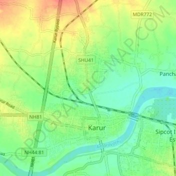
Name: Karur topographic map, elevation, terrain.

Location: Karur, Karur District, Tamil Nadu, India (10.92235 78.02884 11.00011 78.11689)

Average elevation: 129 m

Minimum elevation: 106 m

Maximum elevation: 161 m

Other topographic maps

Click on a map to view its topography, its elevation and its terrain.

Manmangalam

India > Tamil Nadu > Karur

Average elevation: 141 m

Pugalur

India > Tamil Nadu > Karur

Average elevation: 134 m

Gear up for your next adventure:

🥼Base Layers - Thermal base layers for temperature regulation
🧵Survival Paracord - Multi-purpose cordage for emergency repairs and shelters
🎒Backpack Rain Covers - Universal waterproof covers to protect your gear from downpours
🧗Locking Carabiners - Secure gear to your pack or for light technical use
🧥Breathable Waterproof Jackets - Essential rain protection for the unpredictable British climate

As an Amazon Associate, this site earns from qualifying purchases at no extra cost to you.