Geolocate

Ewloe topographic map

Click on the map to display elevation.

About this map

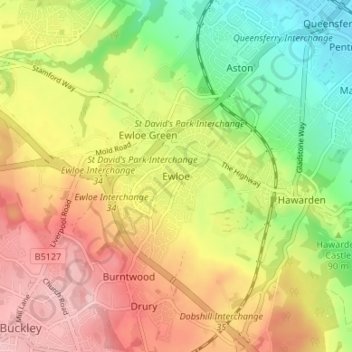
Name: Ewloe topographic map, elevation, terrain.

Location: Ewloe, Flintshire, Wales, CH5 3LY, United Kingdom (53.16744 -3.07051 53.20744 -3.03051)

Average elevation: 84 m

Minimum elevation: 6 m

Maximum elevation: 161 m

Flintshire trails, hiking, mountain biking, running and outdoor activities

Other topographic maps

Click on a map to view its topography, its elevation and its terrain.

Point of Ayr

United Kingdom > Wales > Flintshire > Talacre

Average elevation: 2 m

Ewloe Castle

United Kingdom > Wales > Flintshire > Ewloe

Average elevation: 74 m

Penyffordd

United Kingdom > Wales > Flintshire

Average elevation: 101 m

Bagilt Reservior

United Kingdom > Wales > Flintshire > Bagillt

Average elevation: 32 m

Wepre Park

United Kingdom > Wales > Flintshire > Connah's Quay

Average elevation: 46 m

Saltney

United Kingdom > Wales > Flintshire

Average elevation: 9 m

Nannerch

United Kingdom > Wales > Flintshire > Nannerch

Average elevation: 232 m

Gear up for your next adventure:

🌦️Portable Weather Meters - Handheld tools for monitoring weather conditions
🧤Waterproof Overmitts - Extreme weather protection for hikers and mountaineers
🗺️Ordnance Survey Maps - Essential paper maps for hiking across the UK national parks
🧢Hiking Hats - Sun and weather protection for outdoor walks
🗺️Topographic Maps - Detailed maps showing elevation and terrain features

As an Amazon Associate, this site earns from qualifying purchases at no extra cost to you.