Geolocate

Iwade topographic map

Click on the map to display elevation.

About this map

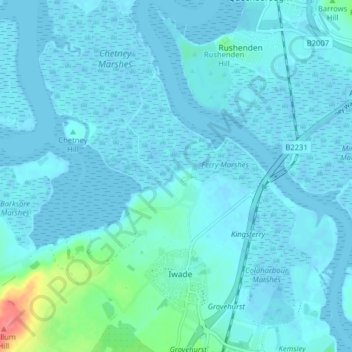
Name: Iwade topographic map, elevation, terrain.

Location: Iwade, Borough of Swale, Kent, England, United Kingdom (51.36561 0.69233 51.41525 0.76622)

Average elevation: 6 m

Minimum elevation: -5 m

Maximum elevation: 63 m

Kent trails, hiking, mountain biking, running and outdoor activities

Other topographic maps

Click on a map to view its topography, its elevation and its terrain.

Sittingbourne

United Kingdom > England > Kent > Borough of Swale

Average elevation: 37 m

The Swale

United Kingdom > England > Kent > Borough of Swale

Average elevation: 12 m

Newhouse

United Kingdom > England > Kent > Borough of Swale

Average elevation: 9 m

Gore

United Kingdom > England > Kent > Borough of Swale > Upchurch

Average elevation: 19 m

Minster

United Kingdom > England > Kent > Borough of Swale

Average elevation: 9 m

Bay View

United Kingdom > England > Kent > Borough of Swale > Warden

Average elevation: 12 m

Keycol Hill

United Kingdom > England > Kent > Borough of Swale

Average elevation: 40 m

Norton Ash

United Kingdom > England > Kent > Borough of Swale > Norton

Average elevation: 30 m

Howt Green

United Kingdom > England > Kent > Borough of Swale > Bobbing

Average elevation: 19 m

Key Street

United Kingdom > England > Kent > Borough of Swale > Borden

Average elevation: 40 m

Wallend

United Kingdom > England > Kent > Borough of Swale > Minster

Average elevation: 7 m

Grove End

United Kingdom > England > Kent > Borough of Swale > Tunstall

Average elevation: 65 m

Trouts

United Kingdom > England > Kent > Borough of Swale > Eastchurch

Average elevation: 24 m

Sittingbourne

United Kingdom > England > Kent > Borough of Swale

Average elevation: 37 m

Uplees

United Kingdom > England > Kent > Borough of Swale

Average elevation: 5 m

Hook's Hole

United Kingdom > England > Kent > Borough of Swale > Borden

Average elevation: 45 m

Oare Creek

United Kingdom > England > Kent > Borough of Swale > Faversham > Oare

Average elevation: 6 m

Norton

United Kingdom > England > Kent > Borough of Swale

Average elevation: 35 m

Seed

United Kingdom > England > Kent > Borough of Swale > Doddington

Average elevation: 101 m

Graveney

United Kingdom > England > Kent > Borough of Swale

Average elevation: 8 m

Halfway

United Kingdom > England > Kent > Borough of Swale

Average elevation: 6 m

Lewson Street

United Kingdom > England > Kent > Borough of Swale > Norton

Average elevation: 36 m

Dargate

United Kingdom > England > Kent > Borough of Swale

Average elevation: 40 m

Oversland

United Kingdom > England > Kent > Borough of Swale

Average elevation: 73 m

Ham Green

United Kingdom > England > Kent > Borough of Swale > Upchurch

Average elevation: 4 m

Gear up for your next adventure:

🥾Women's Waterproof Hiking Boots - High-performance trekking boots designed for all-weather comfort
🍲Portable Camping Stoves - Fast-boiling stoves for hot meals on remote topographic survey trips
🦶Anti-Blister Balms - Protect your feet before long topographic expeditions
🧦Merino Wool Hiking Socks - Moisture-wicking socks to prevent blisters during long mountain walks
🧼Technical Clothing Wash - Special soap to clean and restore waterproof membranes

As an Amazon Associate, this site earns from qualifying purchases at no extra cost to you.