
Gongju-si topographic map
Interactive map
Click on the map to display elevation.
About this map
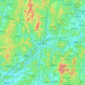
Name: Gongju-si topographic map, elevation, terrain.
Location: Gongju-si, South Korea (36.27515 126.88414 36.67946 127.28253)
Average elevation: 132 m
Minimum elevation: 2 m
Maximum elevation: 822 m
Other topographic maps
Click on a map to view its topography, its elevation and its terrain.
Jungjang-ri
South Korea > Gongju-si > Jungjang-ri
Jungjang-ri, Gongju-si, 32616, South Korea
Average elevation: 203 m