Geolocate

Treuddyn topographic map

Click on the map to display elevation.

About this map

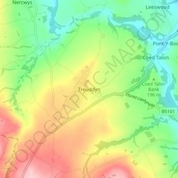
Name: Treuddyn topographic map, elevation, terrain.

Location: Treuddyn, Flintshire, Wales, CH7 4PB, United Kingdom (53.09532 -3.14160 53.13532 -3.10160)

Average elevation: 214 m

Minimum elevation: 134 m

Maximum elevation: 317 m

Flintshire trails, hiking, mountain biking, running and outdoor activities

Other topographic maps

Click on a map to view its topography, its elevation and its terrain.

Penyffordd

United Kingdom > Wales > Flintshire

Average elevation: 101 m

Ewloe Castle

United Kingdom > Wales > Flintshire > Ewloe

Average elevation: 74 m

Bagilt Reservior

United Kingdom > Wales > Flintshire > Bagillt

Average elevation: 32 m

Wepre Park

United Kingdom > Wales > Flintshire > Connah's Quay

Average elevation: 46 m

Saltney

United Kingdom > Wales > Flintshire

Average elevation: 9 m

Point of Ayr

United Kingdom > Wales > Flintshire > Talacre

Average elevation: 2 m

Nannerch

United Kingdom > Wales > Flintshire > Nannerch

Average elevation: 232 m

Gear up for your next adventure:

🎒Hiking Daypacks - Compact backpacks ideal for short hikes and excursions
🥤Hiking Water Bottles - Reusable bottles for hydration on the trail
Insulated Travel Mugs - Keep drinks hot while surveying the landscape from a summit
📱Rugged Phone Cases - Heavy-duty protection for smartphones used as secondary GPS tools
🎒Replacement Sternum Straps - Repair parts for hiking rucksacks

As an Amazon Associate, this site earns from qualifying purchases at no extra cost to you.