
Engelberg topographic map
Click on the map to display elevation.
Engelberg
The average altitude of Engelberg is 1,020 m (3,350 ft). However the village is surrounded by the Alps, creating very steep terrain. The highest point in the borders of the municipality is the Titlis. The Engelberg Valley (German: Engelbergertal) is drained by the Engelberger Aa, a tributary of Lake Lucerne. The valley is located southwards from the lake.
About this map
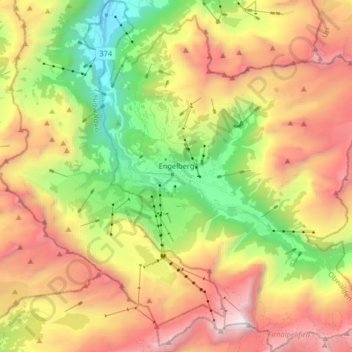
Name: Engelberg topographic map, elevation, terrain.
Location: Engelberg, Obwalden, Switzerland (46.76342 8.36130 46.87459 8.50688)
Average elevation: 1,806 m
Minimum elevation: 561 m
Maximum elevation: 3,233 m
Other topographic maps
Click on a map to view its topography, its elevation and its terrain.