Geolocate

Scorțeni topographic map

Interactive map

Click on the map to display elevation.

About this map

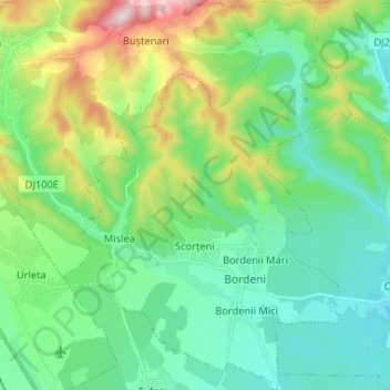
Name: Scorțeni topographic map, elevation, terrain.

Location: Scorțeni, Prahova, Romania (45.05871 25.80534 45.15057 25.90194)

Average elevation: 401 m

Minimum elevation: 273 m

Maximum elevation: 760 m

Other topographic maps

Click on a map to view its topography, its elevation and its terrain.

Teșila

Romania > Prahova

Average elevation: 882 m

Udrești

Romania > Prahova

Average elevation: 283 m

Barajul Paltinu

Romania > Prahova > Brebu

Average elevation: 741 m

Valea Unghiului

Romania > Prahova

Average elevation: 371 m

Drajna de Sus

Romania > Prahova

Average elevation: 467 m

Țintea

Romania > Prahova > Băicoi

Average elevation: 279 m

Zăganu

Romania > Prahova

Average elevation: 1,474 m

Omu

Romania > Prahova > Bușteni

Average elevation: 2,202 m

Ogretin

Romania > Prahova

Average elevation: 485 m

Trăisteni

Romania > Prahova

Average elevation: 907 m

Românești

Romania > Prahova

Average elevation: 116 m

Cătunu

Romania > Prahova

Average elevation: 502 m

Câmpina

Romania > Prahova

Average elevation: 463 m

Ciucaș

Romania > Prahova

Average elevation: 1,605 m

Măgureni

Romania > Prahova > Măgureni

Average elevation: 363 m

Măneciu

Romania > Prahova

Average elevation: 1,058 m

Cornu de Jos

Romania > Prahova

Average elevation: 488 m

Măgurele

Romania > Prahova > Măgurele

Average elevation: 276 m

Chiojdeanca

Romania > Prahova > Chiojdeanca

Average elevation: 321 m