
East Lampeter Township topographic map
Interactive map
Click on the map to display elevation.
About this map
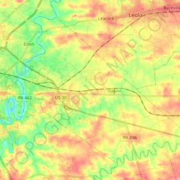
Name: East Lampeter Township topographic map, elevation, terrain.
Average elevation: 111 m
Minimum elevation: 72 m
Maximum elevation: 148 m
Other topographic maps
Click on a map to view its topography, its elevation and its terrain.
Smithville
United States > Pennsylvania > Lancaster County > Providence Township
Average elevation: 140 m
Reinholds
United States > Pennsylvania > Lancaster County > West Cocalico Township
Average elevation: 159 m
Stevens
United States > Pennsylvania > Lancaster County > West Cocalico Township
Average elevation: 121 m
Coopersville
United States > Pennsylvania > Lancaster County > Sadsbury Township
Average elevation: 183 m
Baumgardner
United States > Pennsylvania > Lancaster County > Pequea Township
Average elevation: 126 m
Welsh Mountain
United States > Pennsylvania > Lancaster County > Caernarvon Township
Average elevation: 233 m
Safe Harbor
United States > Pennsylvania > Lancaster County > Conestoga Township
Average elevation: 103 m
Churchtown
United States > Pennsylvania > Lancaster County > Caernarvon Township
Average elevation: 163 m
Brooklawn
United States > Pennsylvania > Lancaster County > Manheim Township > Neffsville
Average elevation: 116 m
Bowling Green
United States > Pennsylvania > Lancaster County > Manor Township
Average elevation: 107 m
Reinholds
United States > Pennsylvania > Lancaster County > West Cocalico Township
Average elevation: 159 m
Stevens
United States > Pennsylvania > Lancaster County > West Cocalico Township
Average elevation: 121 m
Chestnut Ridge
United States > Pennsylvania > Lancaster County > Rohrerstown > Chestnut Ridge
Average elevation: 122 m
Brownstown
United States > Pennsylvania > Lancaster County > West Earl Township
Average elevation: 102 m
Landisville
United States > Pennsylvania > Lancaster County > East Hempfield Township
Average elevation: 122 m