
Ronks topographic map
Interactive map
Click on the map to display elevation.
About this map
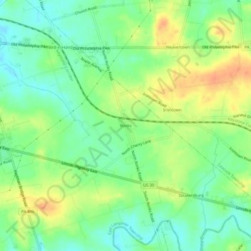
Name: Ronks topographic map, elevation, terrain.
Location: Ronks, Lancaster County, Pennsylvania, 17572, United States (40.00621 -76.18857 40.04621 -76.14857)
Average elevation: 115 m
Minimum elevation: 97 m
Maximum elevation: 138 m
Other topographic maps
Click on a map to view its topography, its elevation and its terrain.
Paradise
United States > Pennsylvania > Lancaster County > Paradise Township > Paradise
Average elevation: 122 m
Columbia
United States > Pennsylvania > Lancaster County
It has a hot-summer humid continental climate (Dfa), and average monthly temperatures range from 30.9 °F (−0.6 °C) in January to 75.8 °F (24.3 °C) in July. The hardiness zone is 6b or 7a depending upon elevation.
Average elevation: 104 m
Columbia
United States > Pennsylvania > Lancaster County
It has a hot-summer humid continental climate (Dfa), and average monthly temperatures range from 30.9 °F (−0.6 °C) in January to 75.8 °F (24.3 °C) in July. The hardiness zone is 6b or 7a depending upon elevation.
Average elevation: 105 m