
Matuku topographic map
Interactive map
Click on the map to display elevation.
Matuku
Matuku is a volcanic island in the Moala subgroup of Fiji's Lau archipelago. Located at 19.18° South and 179.75° East, Matuku covers an area of 57 square kilometers. It has a maximum elevation of 385 meters. Matuku is part of a group of islands known as Yasayasa Moala.
About this map
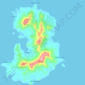
Name: Matuku topographic map, elevation, terrain.
Location: Matuku, Eastern, Fiji (-19.19331 179.72882 -19.11718 179.79017)
Average elevation: 33 m
Minimum elevation: -4 m
Maximum elevation: 380 m
Other topographic maps
Click on a map to view its topography, its elevation and its terrain.
Ono-i-Lau
The group forms one of the southernmost of the Lau Islands; it is located at 20.80° South and 178.75° West, and occupies an area of 7.9 square kilometres (3.1 square miles). It has a maximum elevation of 113 metres (371 feet). It is 90 kilometres (56 mi) south-southwest of Vatoa, the nearest largish island;…
Average elevation: 5 m