
Ķekavas pagasts topographic map
Interactive map
Click on the map to display elevation.
About this map
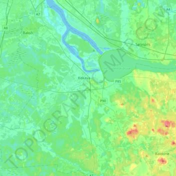
Name: Ķekavas pagasts topographic map, elevation, terrain.
Location: Ķekavas pagasts, Ķekava, Ķekavas novads, Vidzeme, Latvia (56.71755 24.00761 56.91006 24.36941)
Average elevation: 17 m
Minimum elevation: -2 m
Maximum elevation: 79 m
Other topographic maps
Click on a map to view its topography, its elevation and its terrain.
Plakanciems
Latvia > Vidzeme > Ķekavas novads > Ķekavas pagasts
Plakanciems, Ķekavas pagasts, Ķekavas novads, Vidzeme, Latvia
Average elevation: 11 m