
Anchal topographic map
Interactive map
Click on the map to display elevation.
About this map
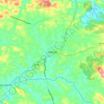
Name: Anchal topographic map, elevation, terrain.
Location: Anchal, Punalur, Kollam, Kerala, 691306, India (8.88927 76.86650 8.96927 76.94650)
Average elevation: 79 m
Minimum elevation: 28 m
Maximum elevation: 196 m
Other topographic maps
Click on a map to view its topography, its elevation and its terrain.
Achankovil
Achankovil, Punalur, Kollam District, Kerala, India
Average elevation: 177 m
Kulathupuzha
Kulathupuzha, Punalur, Kollam District, Kerala, 691310, India
Average elevation: 150 m
Thenmala Dam
India > Kerala > Punalur > Thenmala
Thenmala Dam, Thenmala, Punalur, Kollam, Kerala, India
Average elevation: 155 m
Vellor Ela Thodu
Vellor Ela Thodu, Punalur, Kollam, Kerala, 691548, India
Average elevation: 77 m
Kulathupuzha
Kulathupuzha, Punalur, Kollam, Kerala, 691310, India
Average elevation: 226 m
Shendurney WLS
India > Kerala > Punalur > Thenmala
Shendurney WLS, Thenmala, Punalur, Kollam, Kerala, India
Average elevation: 367 m