

Riyadh Region topographic map
Click on the map to display elevation.
About this map
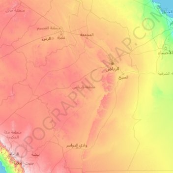
Name: Riyadh Region topographic map, elevation, terrain.
Location: Riyadh Region, Saudi Arabia (19.20833 41.68113 27.70210 48.25820)
Average elevation: 680 m
Minimum elevation: 0 m
Maximum elevation: 2,640 m
Other topographic maps
Click on a map to view its topography, its elevation and its terrain.
Riyadh
Riyadh has a hot desert climate (Köppen Climate Classification BWh), with long, extremely hot summers and short, very mild winters. The average high temperature in August is 43.6 °C (110.5 °F). If it was not for the elevation the city was on, Riyadh would experience an even hotter climate. The city…
Average elevation: 630 m
Mecca
Saudi Arabia > Makkah Region > Makkah Al Mukarramah > Mecca
Mecca is at an elevation of 277 m (909 ft) above sea level, and approximately 80 km (50 mi) inland from the Red Sea. Central Mecca lies in a corridor between mountains, which is often called the "Hollow of Mecca". The area contains the valley of Al Taneem, the Valley of Bakkah and the valley of Abqar. This…
Average elevation: 313 m
Al Bahah
Saudi Arabia > Al-Bahah Province
Al-Baha is the homeland of the Ghamid and Zahran tribes and is divided geographically into three distinct parts: Sarah, which contains the high Hejaz Mountains characterized by temperate weather and rich plant cover due to relatively high annual rainfall, the Tihamah which is the lowland coastal area to the…
Average elevation: 1,744 m


Abha
Abha is located in the southern region of Asir at an elevation of about 2,270 metres (7,450 feet) above sea level. Abha lies on the western edge of Mount Al-Hijaz, near Jabal Sawda, the highest peak in Saudi Arabia. Treating the Asir Mountains as part of the Sarawat, the landscape is otherwise dominated by the…
Average elevation: 1,994 m


Medina
Saudi Arabia > Medina Province
Medina is located in the Hejaz region which is a 200 km (124 mi) wide strip between the Nafud desert and the Red Sea. Located approximately 720 km (447 mi) northwest of Riyadh which is at the center of the Saudi desert, the city is 250 km (155 mi) away from the west coast of Saudi Arabia and at an elevation of…
Average elevation: 692 m


Riyadh
It is the largest city on the Arabian Peninsula and is situated in the center of the Nafud desert, on the eastern part of the Najd plateau. The city sits at an average elevation of 600 meters (2,000 ft) above sea level, and receives around 5 million tourists each year, making it the forty-ninth most visited…
Average elevation: 630 m






Riyadh
It is the largest city on the Arabian Peninsula and is situated in the center of the Nafud desert, on the eastern part of the Najd plateau. The city sits at an average elevation of 600 meters (2,000 ft) above sea level, and receives around 5 million tourists each year, making it the forty-ninth most visited…
Average elevation: 630 m


Medina
Saudi Arabia > Medina Province
Medina is located in the Hejaz region which is a 200 km (120 mi) wide strip between the Nafud desert and the Red Sea. Located approximately 720 km (450 mi) northwest of Riyadh which is at the center of the Saudi desert, the city is 250 km (160 mi) away from the west coast of Saudi Arabia and at an elevation of…
Average elevation: 692 m
`Ar`ar
Saudi Arabia > Northern Borders Province
Arar lies within a vast rocky limestone plain characterized by arid desert landscapes. The city's elevation is approximately 536 meters (1,759 feet) above sea level.
Average elevation: 565 m

Abha
Abha is located in the southern region of Asir at an elevation of about 2,270 metres (7,450 feet) above sea level. Abha lies on the western edge of Mount Al-Hijaz, near Jabal Sawda, the highest peak in Saudi Arabia. Treating the Asir Mountains as part of the Sarawat, the landscape is otherwise dominated by the…
Average elevation: 1,994 m
Riyadh
Riyadh has a hot desert climate (Köppen Climate Classification BWh), with long, extremely hot summers and short, very mild winters. The average high temperature in August is 43.6 °C (110.5 °F). If it was not for the elevation the city was on, Riyadh would experience an even hotter climate. The city…
Average elevation: 630 m


At Ta'if
Taif (Arabic: اَلطَّائِفُ, romanized: aṭ-Ṭāʾif, lit. 'The circulated or encircled', Hejazi pronunciation: [atˤˈ tˤaːjɪf]) is a city and governorate in the Makkan Region of Saudi Arabia. Located at an elevation of 1,879 m (6,165 ft) in the slopes of the Hijaz Mountains, which…
Average elevation: 1,742 m







Riyadh
Riyadh has a hot desert climate (Köppen Climate Classification BWh), with long, extremely hot summers and short, very mild winters. The average high temperature in July is 43.9 °C (111.0 °F). If not for its elevation Riyadh would experience an even hotter climate. The city experiences very little…
Average elevation: 630 m

Riyadh
It is the largest city on the Arabian Peninsula and is situated in the eastern part of the Najd plateau. The city sits at an average elevation of 600 meters (2,000 ft) above sea level, and receives around 5 million tourists each year, making it the forty-ninth most visited city in the world and the sixth in…
Average elevation: 630 m


Jabal al Lawz
Between 1300 and 2200 meters elevation, Jabal al-Lawz has relict Mediterranean woodlands of Juniperus phoenicea, with an understory of Achillea santolinoides, Artemisia sieberi, and Astracantha echinus subsp. arabica.
Average elevation: 1,993 m
At Ta'if
Taif (Arabic: اَلطَّائِفُ, romanized: Aṭ-Ṭāʾif, lit. 'The circulated or encircled', Hejazi Arabic pronunciation: [atˤˈ tˤaː(j)ɪf]) is a city and governorate in Mecca Province in Saudi Arabia. Located at an elevation of 1,879 m (6,165 ft) in the slopes of the Hijaz Mountains, which…
Average elevation: 1,742 m
Jabal al Lawz
Between 1300 and 2200 meters elevation, Jabal al-Lawz has relict Mediterranean woodlands of Juniperus phoenicea, with an understory of Achillea santolinoides, Artemisia sieberi, and Astracantha echinus subsp. arabica.
Average elevation: 1,993 m

Jabal Sawda
Jabal Soudah (Arabic: جَبَل ٱلسُّوْدَة jabal as-sūda, pronounced [dʒabal asːawda]) is a peak in the Soudah mountains in Saudi Arabia. Jabal Soudah is officially recognized by the Saudi authorities as the highest point in Saudi Arabia, with an elevation of 3,015 metres (9,892 ft).
Average elevation: 2,773 m


Riyadh
Riyadh has a hot desert climate (Köppen Climate Classification BWh), with long, extremely hot summers and short, very mild winters. The average high temperature in August is 43.6 °C (110.5 °F). If not for the elevation the city was on, Riyadh would experience an even hotter climate. The city experiences…
Average elevation: 630 m

Medina
Saudi Arabia > Medina Province
Medina is located in the Hejaz region which is a 200 km (120 mi) wide strip between the Nafud desert and the Red Sea. Located approximately 720 km (450 mi) northwest of Riyadh which is at the center of the Saudi desert, the city is 250 km (160 mi) away from the west coast of Saudi Arabia and at an elevation of…
Average elevation: 692 m


Al Bahah
Saudi Arabia > Al-Bahah Province
Al-Baha is the homeland of the Ghamid and Zahran tribes and is divided geographically into three distinct parts: Sarah, which contains the high Hejaz Mountains characterized by temperate weather and rich plant cover due to relatively high annual rainfall, the Tihamah which is the lowland coastal area to the…
Average elevation: 1,744 m
Abha
Abha is located in the southern region of Asir at an elevation of about 2,270 metres (7,450 feet) above sea level. Abha lies on the western edge of Mount Al-Hijaz, near Jabal Sawda, the highest peak in Saudi Arabia. Treating the Asir Mountains as part of the Sarawat, the landscape is otherwise dominated by the…
Average elevation: 1,994 m

Najran
Najran has a hot desert climate (Köppen BWh), typical of the Arabian Peninsula. Rainfall is very sporadic, and consists of light individual rainfall. Despite its location in far southern Saudi Arabia, Najran's average temperature is approximately 3.3 °C or 5.9 °F cooler than that of the Saudi capital…
Average elevation: 1,462 m