
Tuman topographic map
Interactive map
Click on the map to display elevation.
About this map
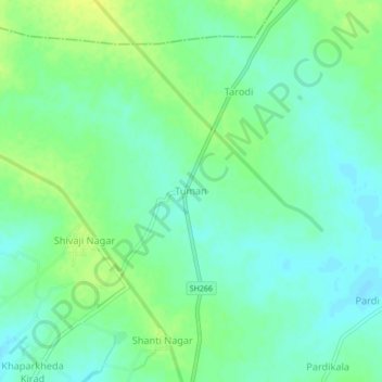
Name: Tuman topographic map, elevation, terrain.
Location: Tuman, Nagpur, Maharastra, India (21.26991 79.39410 21.30991 79.43410)
Average elevation: 289 m
Minimum elevation: 281 m
Maximum elevation: 299 m
Other topographic maps
Click on a map to view its topography, its elevation and its terrain.
Kasani
India > Maharastra > Patan
Kasani, Patan, Satara District, Maharastra, India
Average elevation: 791 m
Rudrapur
India > Maharastra > Sawali
Rudrapur, Sawali, Distrito de Chandrapur, Maharastra, India
Average elevation: 190 m
Pachara
India > Maharastra > Tumsar Taluka
Pachara, Tumsar Taluka, Bhandara, Maharastra, India
Average elevation: 286 m
Jack Fruit
India > Maharastra > Thane
Jack Fruit, Hariom Nagar Road, Neelam Nagar, T Ward, Zone 6, Thane, Mumbai Suburban, Maharastra, 400081, India
Average elevation: 7 m
Mira-Bhayander
India > Maharastra > Mira-Bhayander
Mira-Bhayander, Thane, Maharastra, 401101, India
Average elevation: 40 m
Karjat
India > Maharastra > Karjat
Karjat, Kulāba, Raigad, Maharastra, 410201, India
Average elevation: 109 m