
Muttseehütte topographic map
Interactive map
Click on the map to display elevation.
About this map
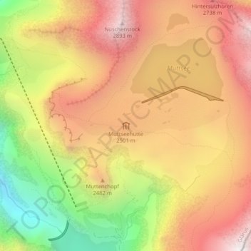
Name: Muttseehütte topographic map, elevation, terrain.
Location: Muttseehütte, 1, Muttenalp, Glarus Süd, Glarus, 8783, Schweiz (46.85739 9.01865 46.85758 9.01888)
Average elevation: 2,348 m
Minimum elevation: 1,574 m
Maximum elevation: 2,931 m
Der Muttsee wurde erstmals ab 1959 mit einem Erddamm zur Energiegewinnung höher gestaut, seit 2014 bietet der See mit einer bis zu 30 Meter hohen Betonstaumauer einen neuen Anblick.
Other topographic maps
Click on a map to view its topography, its elevation and its terrain.
Hätzingen
Schweiz > Glarus > Glarus Süd
Hätzingen, Glarus Süd, Glarus, 8775, Schweiz
Average elevation: 1,035 m
Schwanden
Schweiz > Glarus > Glarus Süd
Schwanden, Glarus Süd, Glarus, 8762, Schweiz
Average elevation: 813 m
Braunwald
Schweiz > Glarus > Glarus Süd > Braunwald
Braunwald, Glarus Süd, Glarus, 8784, Schweiz
Average elevation: 1,215 m
Tierfed
Schweiz > Glarus > Glarus Süd > Tierfed
Tierfed, Glarus Süd, Glarus, 8783, Schweiz
Average elevation: 1,470 m