
Gakenke topographic map
Interactive map
Click on the map to display elevation.
About this map
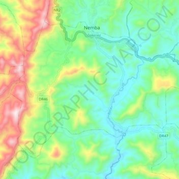
Name: Gakenke topographic map, elevation, terrain.
Location: Gakenke, Northern Province, Rwanda (-1.70444 29.74823 -1.63930 29.83330)
Average elevation: 1,806 m
Minimum elevation: 1,587 m
Maximum elevation: 2,290 m
Other topographic maps
Click on a map to view its topography, its elevation and its terrain.
Kivuruga
Rwanda > Northern Province > Gakenke
Kivuruga, Gakenke, Northern Province, Rwanda
Average elevation: 1,932 m
Coko
Rwanda > Northern Province > Gakenke
Coko, Gakenke, Northern Province, Rwanda
Average elevation: 1,735 m
Rushashi
Rwanda > Northern Province > Gakenke
Rushashi, Gakenke, Northern Province, Rwanda
Average elevation: 1,819 m
Gakenke
Rwanda > Northern Province > Gakenke
Gakenke, Northern Province, Rwanda
Average elevation: 1,796 m