Geolocate

Coko topographic map

Interactive map

Click on the map to display elevation.

About this map

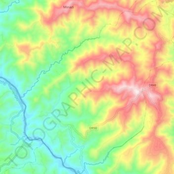
Name: Coko topographic map, elevation, terrain.

Location: Coko, Gakenke, Northern Province, Rwanda (-1.82919 29.76668 -1.73230 29.85610)

Average elevation: 1,735 m

Minimum elevation: 1,369 m

Maximum elevation: 2,240 m

Other topographic maps

Click on a map to view its topography, its elevation and its terrain.

Kivuruga

Rwanda > Northern Province > Gakenke

Kivuruga, Gakenke, Northern Province, Rwanda

Average elevation: 1,932 m

Gakenke

Rwanda > Northern Province > Gakenke

Gakenke, Northern Province, Rwanda

Average elevation: 1,806 m

Rushashi

Rwanda > Northern Province > Gakenke

Rushashi, Gakenke, Northern Province, Rwanda

Average elevation: 1,819 m

Gakenke

Rwanda > Northern Province > Gakenke

Gakenke, Northern Province, Rwanda

Average elevation: 1,796 m