Geolocate

River Dee topographic map

Interactive map

Click on the map to display elevation.

About this map

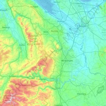
Name: River Dee topographic map, elevation, terrain.

Location: River Dee, Wales, United Kingdom (52.90304 -3.59309 53.25333 -2.85768)

Average elevation: 157 m

Minimum elevation: 0 m

Maximum elevation: 821 m

Wales trails, hiking, mountain biking, running and outdoor activities

Other topographic maps

Click on a map to view its topography, its elevation and its terrain.

Port Talbot

United Kingdom > Wales > Neath Port Talbot

Average elevation: 76 m

Cardiff

United Kingdom > Wales > Cardiff

Average elevation: 55 m

Cambrian Mountains

United Kingdom > Wales > Powys

Average elevation: 319 m

Bethesda

United Kingdom > Wales > Gwynedd

Average elevation: 304 m

Abergavenny

United Kingdom > Wales > Monmouthshire

Average elevation: 187 m

Snowdon

United Kingdom > Wales > Gwynedd

Snowdon (/ˈsnoʊdən/) or Yr Wyddfa (pronounced [ər ˈʊɨ̞̯ðva] (listen)), is the highest mountain in Wales, at an elevation of 1,085 metres (3,560 ft) above sea level, and the highest point in the British Isles outside the Scottish Highlands. It is located in Snowdonia National Park (Parc Cenedlaethol…

Average elevation: 692 m

Newport

United Kingdom > Wales > Newport

Average elevation: 89 m

Swansea

United Kingdom > Wales > Swansea

Much of Swansea is hilly with the main area of upland being located in the council ward of Mawr. Areas up to 185 metres (607 ft) in elevation range across the central section: Kilvey Hill, Townhill and Llwynmawr separate the centre of Swansea from its northern suburbs. Cefn Bryn, a ridge of high land, is the…

Average elevation: 73 m

Cwmhiraeth

United Kingdom > Wales > Carmarthenshire > Waungilwen

Average elevation: 145 m

Llandough

United Kingdom > Wales > Vale of Glamorgan

Average elevation: 56 m

Treffgarne

United Kingdom > Wales > Pembrokeshire

Average elevation: 75 m

Brecon

United Kingdom > Wales > Powys

Average elevation: 216 m

New Quay

United Kingdom > Wales > Ceredigion

Average elevation: 48 m

Wrexham

United Kingdom > Wales > Wrexham

Average elevation: 139 m

Hanmer

United Kingdom > Wales > Wrexham

Average elevation: 84 m

Glyn Ceiriog

United Kingdom > Wales > Wrexham

Average elevation: 333 m

Hay on Wye

United Kingdom > Wales > Powys

Average elevation: 199 m

Llangadog

United Kingdom > Wales > Carmarthenshire

Average elevation: 65 m

Aberangell

United Kingdom > Wales > Gwynedd

Average elevation: 176 m

Llanberis

United Kingdom > Wales > Gwynedd

Average elevation: 322 m

Penallt

United Kingdom > Wales > Monmouthshire

Average elevation: 174 m

Llanelli

United Kingdom > Wales > Carmarthenshire

Average elevation: 41 m

Llanwern

United Kingdom > Wales > Newport

Average elevation: 26 m

Soar

United Kingdom > Wales > Powys

Average elevation: 289 m

Saron

United Kingdom > Wales > Carmarthenshire

Average elevation: 97 m

Rhydargaeau

United Kingdom > Wales > Carmarthenshire

Average elevation: 152 m

Llansteffan

United Kingdom > Wales > Carmarthenshire

Average elevation: 46 m

Druid

United Kingdom > Wales > Denbighshire > Melin Rûg

Average elevation: 199 m

Bala

United Kingdom > Wales > Gwynedd

Average elevation: 273 m

Rhosneigr

United Kingdom > Wales > Isle of Anglesey

Average elevation: 5 m

Knighton

United Kingdom > Wales > Powys

The town became a borough in 1203, with a charter permitting a weekly market and annual fair. The presence of two castles within a comparatively small town suggests that one (the earlier motte and bailey sited atop the town) went out of use before the establishment of the second (the motte with no bailey at…

Average elevation: 295 m

Blaenrhondda

United Kingdom > Wales > Rhondda Cynon Taf

Average elevation: 394 m

Penegoes

United Kingdom > Wales > Powys

Average elevation: 85 m

Glan-y-wern

United Kingdom > Wales > Ceredigion > Borth

Average elevation: 40 m

Llanfair Clydogau

United Kingdom > Wales > Ceredigion

Average elevation: 203 m

Betws Ifan

United Kingdom > Wales > Ceredigion

Average elevation: 143 m

Aberporth

United Kingdom > Wales > Ceredigion

Average elevation: 62 m

Felinwynt

United Kingdom > Wales > Ceredigion

Average elevation: 113 m

Moel Famau

United Kingdom > Wales > Denbighshire

Average elevation: 375 m

Llangan

United Kingdom > Wales > Vale of Glamorgan

Average elevation: 62 m

Swansea

United Kingdom > Wales > Swansea

Much of Swansea is hilly, with the main area of upland being located in the council ward of Mawr. Areas up to 185 metres (607 ft) in elevation range across the central section: Kilvey Hill, Townhill and Llwynmawr separate the centre of Swansea from its northern suburbs. Cefn Bryn, a ridge of high land, is the…

Average elevation: 73 m

Garnfadryn

United Kingdom > Wales > Gwynedd

Average elevation: 114 m

Blaenwaun

United Kingdom > Wales > Carmarthenshire

Average elevation: 188 m

Llowes

United Kingdom > Wales > Powys

Average elevation: 145 m

Pyle

United Kingdom > Wales > Bridgend County Borough

Average elevation: 66 m

Solva

United Kingdom > Wales > Pembrokeshire

Average elevation: 39 m

Blaenavon

United Kingdom > Wales > Torfaen

Average elevation: 383 m

Efail Fach

United Kingdom > Wales > Neath Port Talbot

Average elevation: 192 m

Soar

United Kingdom > Wales > Gwynedd

Average elevation: 101 m

Clydau

United Kingdom > Wales > Pembrokeshire

Average elevation: 156 m

Glyder Fach

United Kingdom > Wales > Conwy

Average elevation: 663 m

Golan

United Kingdom > Wales > Gwynedd

Average elevation: 143 m

Pontypool

United Kingdom > Wales > Torfaen

Average elevation: 226 m

Chepstow

United Kingdom > Wales > Monmouthshire

Average elevation: 57 m

Ynyslas

United Kingdom > Wales > Ceredigion > Borth

Average elevation: 1 m

Port Talbot

United Kingdom > Wales > Neath Port Talbot

Average elevation: 76 m

Cwmgwrach

United Kingdom > Wales > Neath Port Talbot

Average elevation: 190 m

Gower Peninsula

United Kingdom > Wales > Swansea

Average elevation: 85 m

Chepstow

United Kingdom > Wales > Monmouthshire

Average elevation: 57 m

Stackpole

United Kingdom > Wales > Pembrokeshire

Average elevation: 38 m

Carmarthen

United Kingdom > Wales > Carmarthenshire

Average elevation: 74 m

Porthyrhyd

United Kingdom > Wales > Carmarthenshire

Average elevation: 105 m

Moel Eilio

United Kingdom > Wales > Gwynedd > Llanberis

Average elevation: 401 m

Nant Peris

United Kingdom > Wales > Gwynedd

Average elevation: 394 m

Llansannan

United Kingdom > Wales > Conwy

Average elevation: 250 m

Aberdare

United Kingdom > Wales > Rhondda Cynon Taf

Average elevation: 275 m

Llantrisant

United Kingdom > Wales > Rhondda Cynon Taf

Llantrisant (Welsh pronunciation: [ɬanˈtrɪsant]; "Parish of the Three Saints") is a town and community in the county borough of Rhondda Cynon Taf, Wales. It lies within the historic county boundaries of Glamorgan, on the River Ely and the Afon Clun. The three saints of the town's name are Illtyd, Gwynno,…

Average elevation: 104 m

Soughton

United Kingdom > Wales > Flintshire

Average elevation: 136 m

Burry Green

United Kingdom > Wales > Swansea

Average elevation: 57 m

Bala

United Kingdom > Wales > Gwynedd

Average elevation: 273 m

Llynfaes

United Kingdom > Wales > Isle of Anglesey > Bodwrog

Average elevation: 63 m

Brithdir

United Kingdom > Wales > Gwynedd

Average elevation: 185 m

Snowdon

United Kingdom > Wales > Gwynedd

Snowdon (/ˈsnoʊdən/), or Yr Wyddfa (Welsh: [ər ˈʊɨ̞̯ðva] ), is a mountain in Snowdonia in North Wales. It has an elevation of 1,085 metres (3,560 ft) above sea level, which makes it both the highest mountain in Wales and the highest in the British Isles south of the Scottish Highlands. Snowdon is…

Average elevation: 692 m

Castell

United Kingdom > Wales > Conwy > Tal-y-bont

Average elevation: 108 m

Castell

United Kingdom > Wales > Conwy > Tal-y-bont

Average elevation: 108 m

Llandarcy

United Kingdom > Wales > Neath Port Talbot

Average elevation: 29 m

Tredegar

United Kingdom > Wales > Blaenau Gwent

Average elevation: 373 m

Craig-cefn-parc

United Kingdom > Wales > Swansea

Average elevation: 141 m

Crew Green

United Kingdom > Wales > Powys

Average elevation: 102 m

Llanberis

United Kingdom > Wales > Gwynedd

Average elevation: 322 m

Snowdon

United Kingdom > Wales > Gwynedd

Snowdon (/ˈsnoʊdən/), or Yr Wyddfa (Welsh: [ər ˈʊɨ̞̯ðva] ), is a mountain in Snowdonia in North Wales. It has an elevation of 1,085 metres (3,560 ft) above sea level, which makes it both the highest mountain in Wales and the highest in the British Isles south of the Scottish Highlands. Snowdon is…

Average elevation: 692 m

Cambrian Mountains

United Kingdom > Wales > Powys

Average elevation: 320 m

Carreglefn

United Kingdom > Wales > Isle of Anglesey

Average elevation: 60 m

Llangwm

United Kingdom > Wales > Pembrokeshire

Average elevation: 37 m

Newborough

United Kingdom > Wales > Isle of Anglesey

Average elevation: 19 m

Chepstow

United Kingdom > Wales > Monmouthshire

Average elevation: 57 m

Aberystwyth

United Kingdom > Wales > Ceredigion

Aberystwyth experiences an oceanic climate (Köppen climate classification Cfb) similar to almost all of the United Kingdom. This is particularly pronounced due to its west coast location facing the Irish Sea. Air undergoes little land moderation and so temperatures closely reflect the sea temperature when…

Average elevation: 39 m

Abererch

United Kingdom > Wales > Gwynedd

Average elevation: 27 m

Llandudno

United Kingdom > Wales > Conwy

Average elevation: 19 m

Penglais

United Kingdom > Wales > Ceredigion > Aberystwyth

Average elevation: 56 m

Swansea

United Kingdom > Wales > Swansea

Much of Swansea is hilly, with the main area of upland being located in the council ward of Mawr. Areas up to 185 metres (607 ft) in elevation range across the central section: Kilvey Hill, Townhill and Llwynmawr separate the centre of Swansea from its northern suburbs. Cefn Bryn, a ridge of high land, is the…

Average elevation: 73 m

Dryslwyn

United Kingdom > Wales > Carmarthenshire

Average elevation: 58 m