Geolocate

Comarnic topographic map

Click on the map to display elevation.

Comarnic

The town is situated in the southern foothills of the Carpathian Mountains, close to the interface between the Southern Carpathians and the Eastern Carpathians, at an altitude of 555 m (1,821 ft). It lies towards the southern end of the Prahova Valley, along the Prahova River, in the main on the left bank, but with some of the component villages on the right bank of the river.

Wikipedia (CC-BY-SA 3.0)

About this map

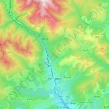
Name: Comarnic topographic map, elevation, terrain.

Location: Comarnic, Prahova, Romania (45.21566 25.53265 45.32260 25.70355)

Average elevation: 885 m

Minimum elevation: 504 m

Maximum elevation: 1,642 m

Other topographic maps

Click on a map to view its topography, its elevation and its terrain.

Barajul Paltinu

Romania > Prahova > Brebu

Average elevation: 741 m

Țintea

Romania > Prahova > Băicoi

Average elevation: 279 m

Valea Unghiului

Romania > Prahova

Average elevation: 371 m

Ogretin

Romania > Prahova

Average elevation: 485 m

Câmpina

Romania > Prahova

Average elevation: 463 m

Omu

Romania > Prahova > Bușteni

Average elevation: 2,202 m

Slon

Romania > Prahova

Average elevation: 729 m

Zăganu

Romania > Prahova

Average elevation: 1,474 m

Arva

Romania > Prahova

Average elevation: 169 m

Omu

Romania > Prahova > Bușteni

Average elevation: 2,202 m

Dâmbu

Romania > Prahova > Băicoi

Average elevation: 300 m

Teșila

Romania > Prahova

Average elevation: 882 m

Schiulești

Romania > Prahova

Average elevation: 628 m

Pietroșani

Romania > Prahova

Average elevation: 103 m

Drajna de Sus

Romania > Prahova

Average elevation: 467 m

Udrești

Romania > Prahova

Average elevation: 283 m

Doftana

Romania > Prahova

Average elevation: 450 m

Găgeni

Romania > Prahova

Average elevation: 257 m

Trăisteni

Romania > Prahova

Average elevation: 924 m

Ciucaș

Romania > Prahova

Average elevation: 1,605 m

Trăisteni

Romania > Prahova

Average elevation: 907 m

Cătunu

Romania > Prahova

Average elevation: 502 m

Românești

Romania > Prahova

Average elevation: 116 m

Chiojdeanca

Romania > Prahova > Chiojdeanca

Average elevation: 321 m

Măneciu

Romania > Prahova

Average elevation: 1,058 m

Ciucaș

Romania > Prahova

Average elevation: 1,605 m

Gear up for your next adventure:

🧼Biodegradable Soap - Leave-no-trace hygiene for multi-day mountain treks
📱Phone Mounts for Hiking - Secure mounts to carry your phone on trails
🧢Thermal Beanie Hats - Prevent heat loss from the head in windy summit conditions
🧺Mesh Stuff Sacks - Breathable storage for wet gear or camp organization
🎒Hiking Backpacks - Comfortable backpacks for day hikes and multi-day treks

As an Amazon Associate, this site earns from qualifying purchases at no extra cost to you.