
Make a donation
Gear up for your next adventure:
As an Amazon Associate, this site earns from qualifying purchases at no extra cost to you.
Mount Suphan topographic map
Click on the map to display elevation.
Make a donation
Gear up for your next adventure:
As an Amazon Associate, this site earns from qualifying purchases at no extra cost to you.
Mount Suphan
Mount Süphan (Turkish: Süphan Dağı; Kurdish: Sîpanê Xelatê; Armenian: Սիփան, Sipan) is a stratovolcano located in eastern Turkey, immediately north of Lake Van. It is the second highest volcano in Turkey, with an elevation of 4,058 metres (13,314 feet), and has the third highest prominence of the Armenian Highlands, after Mount Ararat (5,137 m) and Mount Aragats (4,090 m).
Make a donation
Gear up for your next adventure:
As an Amazon Associate, this site earns from qualifying purchases at no extra cost to you.
About this map
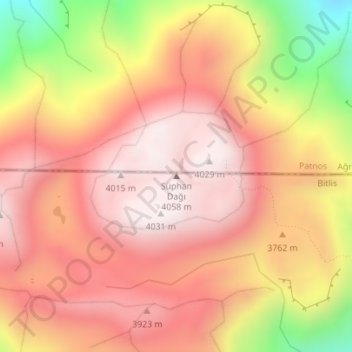
Name: Mount Suphan topographic map, elevation, terrain.
Average elevation: 3,757 m
Minimum elevation: 3,229 m
Maximum elevation: 4,039 m
Make a donation
Gear up for your next adventure:
As an Amazon Associate, this site earns from qualifying purchases at no extra cost to you.