Geolocate

Țicleni topographic map

Interactive map

Click on the map to display elevation.

About this map

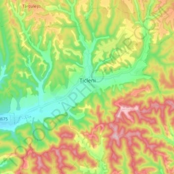
Name: Țicleni topographic map, elevation, terrain.

Location: Țicleni, Gorj, 215600, Roumanie (44.82924 23.32844 44.92958 23.47107)

Average elevation: 260 m

Minimum elevation: 152 m

Maximum elevation: 410 m

Other topographic maps

Click on a map to view its topography, its elevation and its terrain.

Pegeni

Roumanie > Gorj

Pegeni, Hurezani, Gorj, 217262, Roumanie

Average elevation: 267 m

Câmpofeni

Roumanie > Gorj

Câmpofeni, Arcani, Gorj, 217026, Roumanie

Average elevation: 237 m

Stănești

Roumanie > Gorj

Stănești, Gorj, Roumanie

Average elevation: 723 m

Târgu Jiu

Roumanie > Gorj

Târgu Jiu, Gorj, Roumanie

Average elevation: 233 m

Moi

Roumanie > Gorj

Moi, Bâlteni, Gorj, 217062, Roumanie

Average elevation: 171 m

Rânca

Roumanie > Gorj > Rânca

Rânca, Gorj, Roumanie

Average elevation: 1,403 m

Târgu Cărbunești

Roumanie > Gorj

Târgu Cărbunești, Gorj, Roumanie

Average elevation: 278 m