
maloti topographic map
Interactive map
Click on the map to display elevation.
About this map
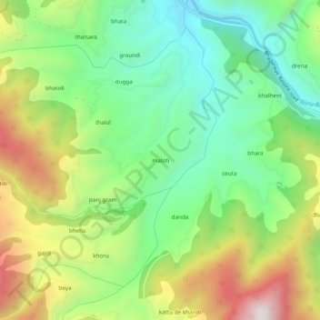
Name: maloti topographic map, elevation, terrain.
Location: maloti, Bhaderwah, Doda district, Jammu and Kashmir, India (33.02878 75.58911 33.06878 75.62911)
Average elevation: 1,525 m
Minimum elevation: 1,194 m
Maximum elevation: 2,058 m
Other topographic maps
Click on a map to view its topography, its elevation and its terrain.
dhalla
India > Jammu and Kashmir > Bhaderwah > dhalla
dhalla, Bhaderwah, Doda District, Jammu and Kashmir, India
Average elevation: 2,097 m