
Make a donation
Gear up for your next adventure:
As an Amazon Associate, this site earns from qualifying purchases at no extra cost to you.
Owens Valley topographic map
Click on the map to display elevation.
Make a donation
Gear up for your next adventure:
As an Amazon Associate, this site earns from qualifying purchases at no extra cost to you.
About this map
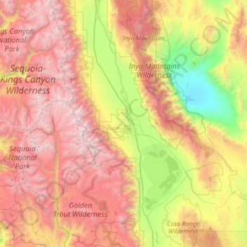
Name: Owens Valley topographic map, elevation, terrain.
Location: Owens Valley, Inyo County, California, United States (36.17340 -118.37858 37.05720 -117.73465)
Average elevation: 2,090 m
Minimum elevation: 323 m
Maximum elevation: 4,398 m
Make a donation
Gear up for your next adventure:
As an Amazon Associate, this site earns from qualifying purchases at no extra cost to you.
Other topographic maps
Click on a map to view its topography, its elevation and its terrain.
Bishop
United States > California > Inyo County
Bishop (formerly Bishop Creek) is a city in California, United States. It is the largest populated place and only incorporated city in Inyo County. Bishop is located near the northern end of the Owens Valley, at an elevation of 4,150 feet (1,260 m). The city was named after Bishop Creek, flowing out of the…
Average elevation: 1,265 m
Lone Pine
United States > California > Inyo County
Lone Pine is a census-designated place (CDP) in Inyo County, California, United States. Lone Pine is located 16 mi (26 km) south-southeast of Independence, at an elevation of 3,727 ft (1,136 m). The population was 2,035 at the 2010 census, up from 1,655 at the 2000 census. The town is located in the Owens…
Average elevation: 1,298 m
Tecopa Hot Springs
United States > California > Inyo County > Tecopa Hot Springs
Average elevation: 426 m
Make a donation
Gear up for your next adventure:
As an Amazon Associate, this site earns from qualifying purchases at no extra cost to you.
Make a donation
Gear up for your next adventure:
As an Amazon Associate, this site earns from qualifying purchases at no extra cost to you.
Independence
United States > California > Inyo County > Independence
Independence is an unincorporated census-designated place in and the county seat of Inyo County, California. Independence is located 41 miles (66 km) south-southeast of Bishop, at an elevation of 3930 feet (1198 m). The population of this census-designated place was 593 at the 2020 census, down from 669 at the…
Average elevation: 1,199 m
Furnace Creek
United States > California > Inyo County > Indian Village
Furnace Creek (formerly Greenland Ranch) is a census-designated place (CDP) in Inyo County, California, United States. The population was 136 at the 2020 census, up from 24 at the 2010 census. The elevation of the village is 190 feet (58 m) below sea level. The visitor center, museum, and headquarters of Death…
Average elevation: 166 m
Make a donation
Gear up for your next adventure:
As an Amazon Associate, this site earns from qualifying purchases at no extra cost to you.
Make a donation
Gear up for your next adventure:
As an Amazon Associate, this site earns from qualifying purchases at no extra cost to you.
Palisade Glacier
United States > California > Inyo County
The Palisade Glacier is a glacier located on the northeast side of the Palisades within the John Muir Wilderness in the central Sierra Nevada of California. The glacier descends from the flanks of four fourteeners, or mountain peaks over 14,000 ft (4,300 m) in elevation, including North Palisade (14,242 ft…
Average elevation: 3,839 m
Make a donation
Gear up for your next adventure:
As an Amazon Associate, this site earns from qualifying purchases at no extra cost to you.
Make a donation
Gear up for your next adventure:
As an Amazon Associate, this site earns from qualifying purchases at no extra cost to you.
Make a donation
Gear up for your next adventure:
As an Amazon Associate, this site earns from qualifying purchases at no extra cost to you.
Make a donation
Gear up for your next adventure:
As an Amazon Associate, this site earns from qualifying purchases at no extra cost to you.
Independence
United States > California > Inyo County
Independence is a census-designated place in Inyo County, California. Independence is located 41 miles (66 km) south-southeast of Bishop, at an elevation of 3930 feet (1198 m). It is the county seat of Inyo County, California. The population of this census-designated place was 669 at the 2010 census, up from…
Average elevation: 1,210 m
Big Pine
United States > California > Inyo County > Big Pine
Big Pine (formerly, Bigpine) is a census-designated place (CDP) in Inyo County, California, United States. Big Pine is located approximately 15 miles (24 km) south-southeast of Bishop, at an elevation of 3,989 feet (1,216 m). The population was 1,756 at the 2010 census, up from 1,350 at the 2000 census. The…
Average elevation: 1,228 m
Make a donation
Gear up for your next adventure:
As an Amazon Associate, this site earns from qualifying purchases at no extra cost to you.
Bishop
United States > California > Inyo County
Bishop (formerly Bishop Creek) is a city in California, United States. It is the largest populated place and only incorporated city in Inyo County. Bishop is located near the northern end of the Owens Valley, at an elevation of 4,150 feet (1,260 m). The city was named after Bishop Creek, flowing out of the…
Average elevation: 1,265 m
Make a donation
Gear up for your next adventure:
As an Amazon Associate, this site earns from qualifying purchases at no extra cost to you.