
Lake Sabrina topographic map
Interactive map
Click on the map to display elevation.
About this map
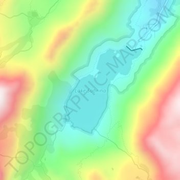
Name: Lake Sabrina topographic map, elevation, terrain.
Location: Lake Sabrina, Inyo County, California, United States (37.19929 -118.62519 37.21232 -118.61064)
Average elevation: 3,033 m
Minimum elevation: 2,730 m
Maximum elevation: 3,492 m
Other topographic maps
Click on a map to view its topography, its elevation and its terrain.
Manzanar National Historic Site
United States > California > Inyo County > Independence
The Manzanar facility was located between Lone Pine and Independence. The weather at Manzanar caused suffering for the inmates, few of whom were accustomed to the extremes of the area's climate. While the majority of people were from the Los Angeles area, some were from places with much different climates…
Average elevation: 1,189 m
Badwater Basin
United States > California > Inyo County
The pool is not the lowest point of the basin: the lowest point (which is only slightly lower) is several miles to the west and varies in position, depending on rainfall and evaporation patterns. The salt flats are hazardous to traverse (in many cases being only a thin white crust over mud), and so the sign…
Average elevation: 152 m
Independence
United States > California > Inyo County
Independence is a census-designated place in Inyo County, California. Independence is located 41 miles (66 km) south-southeast of Bishop, at an elevation of 3930 feet (1198 m). It is the county seat of Inyo County, California. The population of this census-designated place was 669 at the 2010 census, up from…
Average elevation: 1,210 m
Tecopa
United States > California > Inyo County > Tecopa
Tecopa (formerly Brownsville[4]) is a census-designated place (CDP) in the Mojave Desert, in Inyo County, California, United States. Tecopa is located 9 miles (14 km) south-southeast of Shoshone,[4] at an elevation of 1,339 feet (408 m).[3] The population was 150 at the 2010 census, up from 99 at the 2000…
Average elevation: 508 m
Badwater Basin
United States > California > Inyo County
The pool is not the lowest point of the basin: the lowest point (which is only slightly lower) is several miles to the west and varies in position, depending on rainfall and evaporation patterns. The salt flats are hazardous to traverse (in many cases being only a thin white crust over mud), and so the sign…
Average elevation: 152 m