
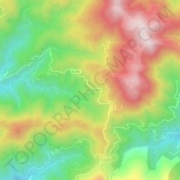
Le Bousquet topographic map
Interactive map
Click on the map to display elevation.
About this map
Name: Le Bousquet topographic map, elevation, terrain.
Average elevation: 608 m
Minimum elevation: 297 m
Maximum elevation: 968 m
Other topographic maps
Click on a map to view its topography, its elevation and its terrain.
Les Combes
France > Occitanie > Gard > Saint-Roman-de-Codières
Les Combes, Saint-Roman-de-Codières, Le Vigan, Gard, Occitanie, France métropolitaine, 30440, France
Average elevation: 614 m
Menhir du Col de Pierre Levée
France > Occitanie > Gard > Saint-Roman-de-Codières > Le Bousquet
Menhir du Col de Pierre Levée, D 290, Le Bousquet, Saint-Roman-de-Codières, Le Vigan, Gard, Occitanie, France métropolitaine, 30440, France
Average elevation: 603 m