Geolocate

Hale topographic map

Click on the map to display elevation.

About this map

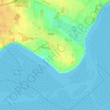
Name: Hale topographic map, elevation, terrain.

Location: Hale, Halton, Liverpool City Region, England, United Kingdom (53.30900 -2.83243 53.34875 -2.76767)

Average elevation: 7 m

Minimum elevation: 0 m

Maximum elevation: 27 m

Halton trails, hiking, mountain biking, running and outdoor activities

Other topographic maps

Click on a map to view its topography, its elevation and its terrain.

Weston

United Kingdom > England > Halton > Runcorn

Average elevation: 27 m

Runcorn

United Kingdom > England > Halton

Average elevation: 22 m

Widnes

United Kingdom > England > Halton

Average elevation: 24 m

Oxmoor Wood

United Kingdom > England > Halton > Runcorn

Average elevation: 12 m

Preston on the Hill

United Kingdom > England > Halton

Average elevation: 50 m

Gear up for your next adventure:

🧭Professional Hiking Compasses - High-precision liquid-filled compasses for map reading and orientation
🧤Hiking Gloves - Warm and durable gloves for cold-weather walks
🥾Women's Waterproof Hiking Boots - High-performance trekking boots designed for all-weather comfort
🐕Hiking Dog Harnesses - Rugged harnesses for taking your companion on mountain trails
🍳Camping Stoves - Compact stoves for outdoor cooking

As an Amazon Associate, this site earns from qualifying purchases at no extra cost to you.