
Bromo Tengger Semeru National Park topographic map
Interactive map
Click on the map to display elevation.
Bromo Tengger Semeru National Park
Bromo Tengger Semeru National Park (Indonesian: Taman Nasional Bromo Tengger Semeru; abbreviated as TNBTS) is a national park located in East Java, Indonesia, to the east of Malang and Lumajang, to the south of Pasuruan and Probolinggo, and to the southeast of Surabaya, the capital of East Java. It is the only conservation area in Indonesia that has a sand sea, the Tengger Sand Sea (Indonesian: Laut Pasir Tengger), across which is the caldera of an ancient volcano (Tengger) from which four new volcanic cones have emerged. This unique feature covers a total area of 5,250 hectares at an altitude of about 2,100 meters (6,900 ft). The massif also contains the highest mountain in Java, Mount Semeru (3,676 meters (12,060 ft)), four lakes and 50 rivers. It is named after the Tengger tribe. The explosion of the volcano that created the caldera, happened ca. 45.000 years ago, in an event similar to the Krakatau eruption.
About this map
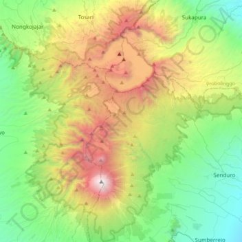
Name: Bromo Tengger Semeru National Park topographic map, elevation, terrain.
Average elevation: 1,343 m
Minimum elevation: 198 m
Maximum elevation: 3,657 m
Other topographic maps
Click on a map to view its topography, its elevation and its terrain.
Kepanjen
Indonesia > East Java > Kabupaten Malang
Kepanjen is located in south center of Malang Regency. Kepanjen has an average altitude of 336 metres (1,102 ft) above sea level. Kepanjen is surrounded by three large mountains: Mount Kawi, Mount Semeru and Southern Malang Mountains.
Average elevation: 337 m
Babadan
Indonesia > East Java > Kabupaten Malang > Dsn. Babadan, Ds. Babadan, Kecamatan Ngajum, Malang
Average elevation: 561 m
Dsn. Blau Ds. Permanu Kec. Pakisaji, Malang
Indonesia > East Java > Kabupaten Malang
Average elevation: 478 m