
Arinsal topographic map
Interactive map
Click on the map to display elevation.
Arinsal
Arinsal (Catalan pronunciation: [əɾinˈzal]) is a village in Andorra, set at an altitude of between 1550 and 2560 metres, close to the border with Spain at Tor, Pallars. In the summer Arinsal is home to walkers and bikers, as well as those who just want to relax in the mountain scenery. In the winter, it offers skiing and snowboarding for beginners, as well as a good selection of runs for intermediates.
About this map
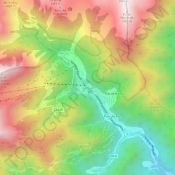
Name: Arinsal topographic map, elevation, terrain.
Location: Arinsal, La Massana, AD400, Andorra (42.55208 1.46440 42.59208 1.50440)
Average elevation: 1,856 m
Minimum elevation: 1,263 m
Maximum elevation: 2,487 m
Other topographic maps
Click on a map to view its topography, its elevation and its terrain.
Pal
It is situated at an altitude of 1,551 m (5,089 ft). The village church, of the 11th century and in Romanesque style, is dedicated to St. Clement. It has a rectangular bell tower with mullioned windows decorated. Above the town, in the forest of Pal, in 1982 was inaugurated the ski resort of Pal, now grouped…
Average elevation: 1,830 m